Launch News SMOS and Proba-2 launch : Monday 2 November, 2009.

Notebook

Addon Developer
Addon Developer
News Reporter
Donator
Joined
Nov 20, 2007
Messages
11,820
Reaction score
641
Points
188

SiberianTiger

News Sifter
News Reporter
Donator
Joined
Feb 13, 2008
Messages
5,398
Reaction score
8
Points
0
Location
Khimki
Website
tigerofsiberia.livejournal.com
ESA%20-%20European%20Space%20Operations%20Center_small.jpg
logoFKA-eng.jpg


smos_m.jpg
proba2_m.jpg


Launch site: Plesetsk
Launch date: November 2, 2009

The launch time is:
4 : 50 : 51 Moscow 02.11.2009
1 : 50 : 51 UTC November 2, 2009
8 : 50 : 51 p.m. EST November 1, 2009

Payload: SMOS, PROBA-2

Spacecraft 1: 
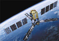
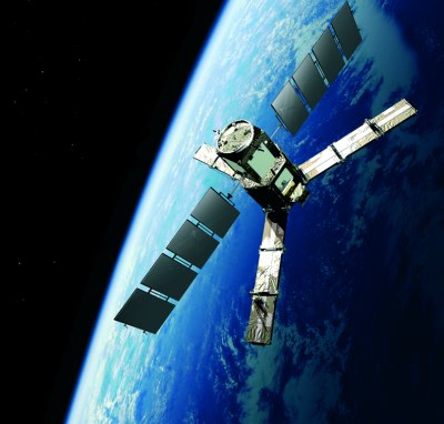
SMOS, Soil Moisture and Ocean Salinity mission
smos_orbit_br_june04_400.jpeg


SMOS is next in the series of ESA’s Earth Explorer missions, which are designed to observe critical Earth system variables.


Designed and built by a European consortium of industry and science, SMOS – also known as ESA’s Water Mission – is the first satellite dedicated to providing global measurements of soil moisture and ocean salinity.


The Earth Explorer missions form the science and research element of the ESA’s Living Planet Programme and focus on the atmosphere, biosphere, hydrosphere, cryosphere and the Earth’s interior, with the overall emphasis on learning more about the interactions between these components and the impact that human activity is having on natural Earth processes.


The first of the ESA ’Earth Explorers’ – GOCE (Gravity Field and Steady-State Ocean Circulation Explorer) – was successfully launched on a Rockot launch vehicle from Plesetsk launch site in March 2009.

Mission Objectives

1. Soil moisture. Accuracy of 4% at a spatial resolution of 50 km and revisit time of 1-3 days. This is comparable to being able to detect one teaspoonful of water mixed into a handful of soil.

2. Ocean salinity. Accuracy of 0.5-1.5 practical salinity units (psu) for a single observation/0.1 psu for a 30-day average for an area 200x200 km, which is comparable to detecting 0.1 g of salt in a litre of water.

Data from SMOS will:

1. Fill the current lack of global and continuous observations of soil moisture and ocean salinity needed to improve our understanding of Earth’s water cycle. This will help understand more about how a changing climate may be affecting patterns of evaporation over the land and oceans. Data from SMOS could improve weather and climate models, and have practical applications in areas such as agriculture and water resource management.

2. Provide, for the first time, regularly-updated ocean salinity mapping from space, furthering our knowledge of ocean circulation patterns and their role in the climate system.

SMOS Spacecraft Specifications

Items|Specs
Application|Soil Moisture and Ocean Salinity Observation
Orbit Type|Low-Earth, polar, Sun-synchronous, quasi-circular, dusk-dawn, 23-day repeat cycle, 3-day sub-cycle
Orbit Inclination|98.44°
Mean Altitude|758 km
Lifetime|Three years (including a six-month commissioning phase) with a possible two-year extension
Mass|658 kg (Proteus platform: 275 kg, payload: 355 kg, fuel: 28 kg)
Configuration/Dimensions at launch|Satellite platform (approx. 1 m3) with deployable solar generator panels and interface towards the launch vehicle. The payload module (appox.1m3) is mounted on top of the platform. Overall dimensions in launch configuration fit into a cylinder 2.4 m high and 2.3 m in diameter
Payload|Microwave Imaging Radiometer using Aperture Synthesis (MIRAS) – the first spaceborne, 2D interferometric L-band radiometer operating at 1.4 GHz (21 cm wavelength), with 69 antenna receivers distributed on a Y-shaped deployable antenna array and central hub. H and V polarizations measured sequentially. MIRAS will make global observations of emitted microwave radiation through almost all atmospheric conditions, at least once every three days
Power|Maximum available for satellite: 1,065 W; Maximum consumption for MIRAS payload: 511 W; Proteus platform battery: 78 A·h Li-Ion
Propulsion|Hydrazine
Stabilization|3-axis stabilized
Satellite Attitude|32.5 degrees forward tilt in flight direction, local normal pointing and yaw steering
Control and Navigation|Star-trackers, gyros, magnetometers, GPS, Sun sensors; Reaction wheels, magnetotorquers, 4x1-N thrusters
Communication links|X-band downlink for science data to ESA’s European Space Astronomy Centre (ESAC) in Villafranca, Spain, complemented by an X-band station in Svalbard, Norway, for acquisition of near-realtime data products; S-band uplink (4 kbps) and downlink (722 kbps) to Kiruna, Sweden, for satellite telemetry and telecommand (generic Proteus ground station)
Command and Control|Platform integrated data handling, and Attitude and Orbit Control system computer that interfaces with the payload’s own control and correlator unit via a 1,533 bus and serial links
Mission control|CNES Proteus Control and Command Centre in Toulouse, France, via CNES S-band ground station network – Kiruna in Sweden, Aussaguel in France and Kourou in French Guiana Flight Operations
Data processing|Data Processing Centre at ESAC, long-term archive at Kiruna, and User Services via ESA’s Centre for Earth Observation ESRIN in Frascati, Italy
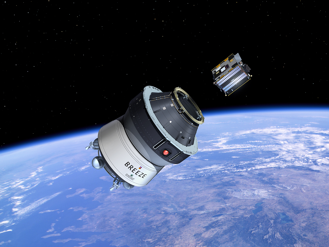
Launch Vehicle|Rockot with Breeze KM upper stage
Owner and Operator|SMOS is an ESA Earth Explorer mission with national contributions provided by the French and Spanish space agencies, CNES and CDTI. For the operations phase, ESA will be responsible for the overall coordination of the mission and the ground segment operations, whereas CNES will operate the spacecraft
Launch Services Provider|Eurockot Launch Services, Bremen, Germany
Satellite Manufacturers|The design and construction of SMOS involved more than 20 European companies and was led by EADS CASA Espacio (Spain) for the payload and Thales Alenia Space Industries (France) for the satellite (Proteus platform adapted to the needs of the SMOS mission)
Launch Vehicle Manufacturer|Khrunichev State Research and Production Space Center, Moscow, Russia
Launch Site|Plesetsk Cosmodrome, Russia
Launch|November 2, 2009

Instrument

miras_400.jpeg
licef_400.jpeg


See deployment animation at: http://www.esa.int/SPECIALS/smos/SEM23K6CTWF_0.html

One of the biggest challenges in developing the SMOS mission was to fly and demonstrate an instrument that would measure microwave radiation emitted from Earth’s surface within the ‘L-band’, around a frequency of 1.4 GHz. This frequency provides the best sensitivity to variations of moisture in the soil and changes in the salinity of the ocean, coupled with minimal disturbance from weather, atmosphere and vegetation cover.

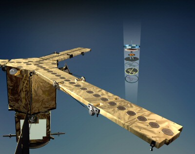
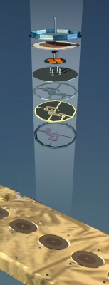
In order to achieve the spatial resolution required for observing soil moisture and ocean salinity, the laws of physics mean that to take measurements in L-band, a huge antenna would have been required – too big for a satellite to carry. To overcome this challenge, the Microwave Imaging Radiometer with Aperture Synthesis (MIRAS) instrument was developed. Here the size of the antenna needed has been simulated through 69 small antennas, distributed over the three arms and central hub of the instrument.

The three deployable arms are folded up for launch, but once SMOS is in orbit each of the arms fold out into an unusual three-pointed star shape. Hence, with a diameter of eight metres, MIRAS is often dubbed a ‘star in the sky’.

The 69 antenna elements, called LICEFs, are antenna-receiver integrated units, each measure radiation emitted from Earth’s surface at L-band. One LICEF antenna weighs 190 g, is 165 mm in diameter and 19 mm high.

MIRAS was built by a consortium of over 20 European companies led by EADS-CASA Espacio in Spain.
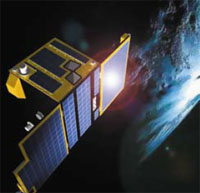
Spacecraft 2: PROBA-2
Proba2-1-HR_large,0.jpg


Proba stands for PRoject for OnBoard Autonomy. The Proba satellites are among the smallest spacecraft ever to be flown by ESA, but they are making a big impact in the field of space technology. The Proba satellites are part of ESA’s In orbit Technology Demonstration Programme: missions dedicated to the demonstration of innovative technologies. In orbit demonstration is the final step on the technology development ladder. In orbit demonstration is achieved through experiments on carriers of opportunity, e.g. the International Space Station, or through dedicated small satellites such as the Proba series, which were created to increase the availability of flight-testing opportunities. Proba-2 is the second of the series, building on nearly eight years of successful Proba-1 experience.

Altogether, 17 new technological developments and four scientific experiments, focused on solar and space weather observations, are being flown on Proba-2.

The technology demonstrations are:

1. a new type of lithium-ion battery, developed by SAFT (FR);
2. an advanced data and power management system, containing many new component technologies including the LEON processor developed by Verhaert Space (BE);
3. combined carbon-fibre and aluminum structural panels, developed by Apco Technologies SA (CH);
4. new models of reaction wheels from Dynacon (CA), star trackers from DTU (DK) and GPS receivers from DLR (DE);
5. an upgraded telecommand system with a decoder largely implemented in software by STT-SystemTechnik GmbH (DE);
6. a digital Sun-sensor, developed by TNO (NL);
7. a dual-frequency GPS receiver, developed by Alcatel Espace (FR);
8. a fibre-sensor system for monitoring temperatures and pressures around the spacecraft, developed by MPB Communications Inc. (CA);
9. a new star tracker system, used in BepiColombo project (Galileo Avionica, Italy);
10. a new star-tracker development being test-flown before use on the BepiColombo mission, developed by Galileo Avionica (IT);
11. a very high precision flux-gate magnetometer, developed by DTU (DK);
12. an experimental solar panel with a solar flux concentrator, developed by CSL (BE);
13. a xenon gas propulsion system using resistojet thrusters and a solid-state nitrogen gas generator to pressurise the propellant tanks, developed by SSTL (GB) and Bradford (NL);
14. an exploration micro-camera (X-CAM), developed by Space-X (CH);
15. new GNC algorithms developed by NGC (CA);
16. three new high rate three-axis precision magnetometer(s), two analogue Hi-Rel fluxgate and one digital AMR (Anisotropic Magnetic Resistor) magnetometer developed by ZARM Technik AG (DE).

The two solar observation experiments are:

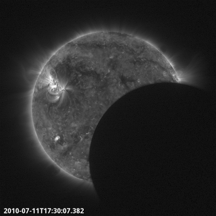
1. a Lyman-Alpha radiator (LYRA) that will monitor four bands in a very wide ultraviolet spectrum, with Centre Spatial de Liege as lead institute supported by the Royal Observatory of Belgium as scientific leader and with an international team comprising PMOD (CH), IMOMEC (BE) and BISA (BE);
2. an extreme-ultraviolet telescope (SWAP) using new pixel sensor technology (APS), that will make measurements of the solar corona in a very narrow band, with Centre Spatial de Liege as lead institute supported by the Royal Observatory of Belgium and with an industrial team comprising Alcatel Lucent (BE), AMOS SA (BE), DELTATEC (BE), Fill Factory NV (BE) and OIP NV (BE).

The two space weather experiments are:

1. Dual Segmented Langmuir Probes (DSLP), which will measure electron density and temperature in the background plasma of the Earth’s magnetosphere;
2. a thermal plasma measurement unit (TPMU), that will measure ion densities and composition.

Both were developed by a Czech consortium, led by the Institute of Atmospheric Physics, Academy of Sciences of the Czech Republic (CZ).

Proba-2 Spacecraft Specifications

Items|Specs
Application|Technology demonstration mission incorporating 17 new technological developments and four scientific experiments (focused on solar and space weather observations)
Orbit Type|Almost circular, Sun synchronous, dusk-dawn
Orbit Inclination|98.298 degrees
Orbit Altitude|between 700 and 800 km
Nominal Lifetime|2 years
Mass|Approx. 130 kg
Configuration|A 600mm x 700mm x 850mm, box-shaped structure with two deployable solar panels
Attitude control and navigation|The Proba-2 spacecraft is fully three-axis stabilized. Turning moments are supplied by four 30 mN-m Dynacon reaction wheels, which can be unloaded by means of magnetorquers. Attitude determination is performed using an autonomous high-accuracy (5 arcsec over 10 seconds) two-head star tracker, GPS sensors and a three-axis magnetometer. Sun pointing to 100 arcsec accuracy is expected to be achieved
Autonomous navigation|is enabled with GPS position determination and orbit propagation. All the required navigation and manoeuvring computations are performed on-board. A single resist jet thruster, capable of producing a thrust of 20 mN, is being used for orbit adjustment. The thruster uses xenon as the propellant gas and, as the xenon supply is depleted, the tank is re-pressurised with nitrogen from a solid-state gas generator
Power|Power is generated by triple-junction gallium-arsenide solar cells mounted on two deployable panels and one fixed panel. The solar generators provide a maximum of 110 Watts of electrical power at the end of the nominal two-year mission. A 16.5 A·h lithium-ion battery supplies power during eclipses and when specific payload experiments require a peak power greater than the solar generators can supply
The spacecraft’s power consumption varies between 53 and 110 Watts, depending on its mode of operation
Propulsion|Xenon propulsion system with resistojet thruster
Communication links|During normal operations Proba-2 communicates via an S-band link with ESA’s Redu, Belgium, control centre, which is equipped with a 2.4 metre dish antenna. The S-band channel provides a 64 Kbit/s packet telecommand uplink and 1 Mbit/s packet telemetry downlink. The Norwegian ground station on Svalbard is being used during the launch and early orbit (LEOP) phase and to provide extended science data download during the operational mission.
Mission control/ processing/archiving|A dedicated ground station at ESA Redu, in Belgium. Scientific data is distributed from Redu via a web server
Industrial Team|The Prime Contractor for the Proba-2 project is Verhaert Design and Development NV (B), a subsidiary of QinetiQ (UK), who is leading a pan-European team responsible for the development and manufacture of the satellite
Owner and Operator|European Space Agency
Launch Services Provider|Eurockot Launch Services (Bremen, Germany).
Launch Vehicle|Rockot (with Breeze KM upper stage)
Launch Vehicle Manufacture|Khrunichev State Research and Production Space Center (Moscow, Russia)
Launch Site|Plesetsk Cosmodrome, Russia
Launch|November 2009. The spacecraft will be a secondary passenger during the launch of ESA’s Soil Moisture and Ocean Salinity (SMOS) mission

Proba2-3-LR-2.jpg
 

SiberianTiger

News Sifter
News Reporter
Donator
Joined
Feb 13, 2008
Messages
5,398
Reaction score
8
Points
0
Location
Khimki
Website
tigerofsiberia.livejournal.com
Launch vehicle: Rokot (meaning Rumble)
rokot-km__1.jpg


Manufacturer: Khrunichev State Research And Production Space Centre
0_2ef8_6b08483e_orig


The Rockot lightweight launch vehicle designed subject to Governmental Decree 925-r consists of three stages. The first two stages are essentially the booster stack of the RS 18 (or, equivalently, SS 19 Stiletto) strategic missile and the Breeze KM is employed as the third stage. A payload fairing has been designed for this launcher to accommodate one or more spacecraft in addition to Breeze KM.

Rockot has a good performance largely due two the Breeze KM upper stage having broad capabilities as far as injection of spacecraft into orbits with different altitudes and/or inclinations is concerned. The Breeze KM equipment can control the spacecraft attitude to a high precision and supply spacecraft with enough power during both ascent and orbital flight lasting up to 7 hrs. A special-purpose system can separate the spacecraft and the upper stage with the minimum possible disturbances.

1_rokot.jpg
rockot.jpg


Rockot Performance
Items|Specs
LV configuration|Three stages Stages 1 & 2: based on SS 19 (RS 18) ICBM booosters Stage 3: Breeze KM upper stage
Lift-off mass (kg)|107,500
Payload parking orbit mass (kg) ( H circ = 200 km , i = 63 ° )|1950 (Breeze KM) 2300 (Breeze KC)
Injection error by Orbit height (%)|+ 1 to 2
Injection error by Inclination (%)|+ 0.03 to 0.05
Payload Fairing diameter/length (m)|2.5 x 2.62 / 6.74
Starting date of flight tests|May 2000 (3 successful missions of close prototypes performed in 1990-1994)
Types/quantities/thrust values (sea level/vacuum) of engines
Descriptions|Values
- Stage 1|15D95 liquid engines/3 ea. + 15D96 /1 ea. / (180,000 kgf / 212,700 kgf)
- Stage 2|15D113 liquid engine /1 ea./ (- / 23,980 kgf) (main) 15D114 liquid engine/(- /1580 kgf) (steering)
- Stage 3|S5.98 liquid engine /1 ea./(-/2000 kgf) (main) 11D458 liquid engines /4 ea./ 40 kgf (vernier) 17D58E liquid engines /12 ea. /1.3 kgf (attitude control and stabilization)

The vehicle's reliability statistics according to http://www.spacelaunchreport.com/reliability2009.txt:

Code:
================================================================ 
Vehicle     Successes/Tries Realzd Pred  Consc. Last     Dates    
                             Rate  Rate* Succes Fail    
================================================================ 
Rokot/Briz/K(M)  11    12    .92  .86      4    10/8/05  1994-

Mission Profile and Timeline

shema_viv_m.jpg

shema2_viv.jpg


Rockot LV working phase SMOS SC and Proba-2 SC injection
uchastokrn.jpg


# of event|Event|Rel Time|Moscow Time
1|End of Inertial Coercion|-0 : 00 : 14.045|4 : 50 : 37
2|Lift-off Contact|0 : 00 : 00.000|4 : 50 : 51
3|1st stage booster sep|0 : 02 : 02.225|4 : 52 : 53
4|Fairing sep|0 : 02 : 43.044|4 : 53 : 34
5|2nd stage booster sep|0 : 05 : 04.995|4 : 55 : 56

paden.jpg


1st Breeze-KM burn: Orbit boosting

# of event|Event|Rel Time|Moscow Time
6|Begin of ullage|0 : 05 : 06.655|4 : 55 : 58
7|ME start|0 : 05 : 10.955|4 : 56 : 02
8|End of ullage|0 : 05 : 12.855|4 : 56 : 04
9|Leaving Contact w Ground|0 : 08 : 21.922|4 : 59 : 13
10|ME cutoff|0 : 15 : 05.285|5 : 05 : 56

2nd Breeze-KM burn

# of event|Event|Rel Time|Moscow Time
11|Begin of ullage|1 : 02 : 35.955|5 : 53 : 27
12|ME2 start|1 : 02 : 40.255|5 : 53 : 31
13|End of ullage|1 : 02 : 42.155|5 : 53 : 33
14|ME2 cutoff|1 : 03 : 45.429|5 : 54 : 36

# of event|Event|Rel Time|Moscow Time
15|SMOS separation|1 : 09 : 52.955|6 : 00 : 44

trassa.jpg


3rd Breeze-KM burn

# of event|Event|Rel Time|Moscow Time
16|1st RCS burn|1 : 23 : 05.955|6 : 13 : 57
17|end of burn|1 : 23 : 23.199|6 : 14 : 14
18|Entering Contact w Ground|1 : 30 : 36.920|6 : 21 : 28
19|Leaving Contact w Ground|1 : 44 : 40.125|6 : 35 : 31

4th Breeze-KM burn

# of event|Event|Rel Time|Moscow Time
20|2nd RCS burn|2 : 06 : 40.955|6 : 57 : 32
21|end of burn|2 : 06 : 57.954|6 : 57 : 49
22|Separation of SMOS Adapter|2 : 16 : 25.955|7 : 07 : 17
23|Separation of PROBA-2|2 : 59 : 14.955|7 : 50 : 06
24|Entering Contact w Ground|3 : 12 : 37.352|8 : 03 : 28

Breeze-KM clearing burn
# of event|Event|Rel Time|Moscow Time
25|Burn's begin|3 : 20 : 05.955|8 : 10 : 57
26|Leaving Contact w Ground|3 : 21 : 06.667|8 : 11 : 58
27|End of burn|3 : 21 : 45.955|8 : 12 : 37

ciclogr.jpg


Weather forecast for Plesetsk, Russia on November 2, 2009

cond129.gif

Hi: 0°
Lo: -1°
Mixture of precip. There is a 30% chance of precipitation. Cloudy. Cold. Temperature of 0°C. Winds WNW 9km. Humidity will be 100% with a dewpoint of 0° and feels-like temperature of -2°C.

Related Blogs / Photo Reports


Watching the launch live


Star Voyager

Space Shuttle Refugee
Joined
Oct 25, 2008
Messages
1,975
Reaction score
32
Points
48
Liftoff of the Rockot launch vehicle with Proba 2 and SMOS for ESA!

---------- Post added at 09:11 PM ---------- Previous post was at 09:02 PM ----------

By the way, is the Breeze sort of like the Russian counterpart of the Centaur upper stage?
 

SiberianTiger

News Sifter
News Reporter
Donator
Joined
Feb 13, 2008
Messages
5,398
Reaction score
8
Points
0
Location
Khimki
Website
tigerofsiberia.livejournal.com

By the way, is the Breeze sort of like the Russian counterpart of the Centaur upper stage?

That's so only if you compare them on the basic functionality: performing an autonomous flight, boosting payload into custom orbit. Briz family stages are substantially smaller than Centaurs and use N2O4+UDMH fuel, but Hydro/LOX.

KVRB family stages are closer counterparts for Centaurs. They are not used on any Russian rockets however, only sold to India for use atop GSLV. Block-DM is also closer to Centaur in payload capability.

---------- Post added at 14:13 ---------- Previous post was at 12:47 ----------

Replay of the launch:
 

orb

New member
News Reporter
Joined
Oct 30, 2009
Messages
14,020
Reaction score
4
Points
0
ESA: Proba-2 fuel tank refilled from ‘solid gas’:
24 August 2011

Sometimes all it takes is fresh air to get a new lease of life. ESA’s Proba-2 microsatellite is a good example: an influx of nitrogen has replenished its fuel tank, in the process demonstrating a whole new space technology.

On 16 August a telecommand was sent from ESA’s Redu ground station in Belgium to boost the gases in Proba-2’s unusual ‘resistojet’ engine.

Used to maintain the microsatellite’s orbit at 600 km altitude, this experimental engine runs on xenon gas heated before ejection to provide added thrust.

The command added nitrogen gas to the fuel tank, bringing its pressure close to its launch level.

{...}
 

N_Molson

Addon Developer
Addon Developer
Donator
Joined
Mar 5, 2010
Messages
9,295
Reaction score
3,265
Points
203
Location
Toulouse
"Proba-2", what a beautiful name ! :hailprobe: :hailprobe:
 

orb

New member
News Reporter
Joined
Oct 30, 2009
Messages
14,020
Reaction score
4
Points
0
ESA: ESA's space weather box Proba-2 tracks stormy Sun:
2 December 2011

Researchers gathered for European Space Weather Week have been presented with the latest results from ESA’s own space weather station: the Proba-2 microsatellite.

The unpredictably stormy Sun drives space weather: surges of charged particles can damage satellites, impede space-based services and affect terrestrial power networks.

Less than a cubic metre, Proba-2 was launched on 2 November 2009 as a technology demonstrator but is now working as a science mission, having exceeded its two-year design life.

Proba-2 science data are also useful for space weather monitoring: two instruments watch the Sun, with two more studying the Sun’s influence on Earth’s topmost ionosphere.

The mission is keeping busy: it has gathered upwards of 400 000 images of the Sun and made almost 20 million in-situ ionospheric observations.

This year’s European Space Weather Week, taking place in the Palais des Congres in Namur, Belgium, from 28 November to 2 December included presentations by users of Proba-2 data from all over Europe.

“Proba-2 science data are also distributed to scientific teams worldwide, from the US to India,” noted Marie Dominique of the Royal Observatory of Brussels, responsible for Proba-2’s Sun-watching sensors.

{...}
 

orb

New member
News Reporter
Joined
Oct 30, 2009
Messages
14,020
Reaction score
4
Points
0
ESA: SMOS detects freezing soil as winter takes grip:
Click on image to enlarge​
SMOS has shown that it is able to detect frozen soil from space. The depth to which the soil is frozen can also be inferred. From the animation, which shows northern Finland, the difference between 26 November 2010 and 26 November 2011 can be seen clearly. This year’s late frost is associated with Europe’s mild weather this autumn.
Credits: Finnish Meteorological Institute​
|
14 December 2011
ESA’s SMOS satellite is designed to observe soil moisture and ocean salinity, but this innovative mission is showing that it can also offer new insight into Earth’s carbon and methane cycles by mapping soil as it freezes and thaws.​
The launch of the Soil Moisture and Ocean Salinity (SMOS) mission in November 2009 opened up a new era of monitoring Earth using a new remote-sensing technique.​
The satellite is capturing images of ‘brightness temperature’. These images correspond to microwave radiation emitted from Earth’s surface and can be related to soil moisture and ocean salinity.​
Variability in soil moisture and ocean salinity is a consequence of the continuous exchange of water between the oceans, the atmosphere and the land – Earth’s water cycle.​

{colsp=2}
Click on images to enlarge​
| Observed by SMOS, the map shows the extent and depth of frozen soil in northern Finland on 26 November 2011.
Credits: Finnish Meteorological Institute​
| Observed by SMOS, the map shows the extent and depth of frozen soil in northern Finland on 30 November 2011, which is considerably greater than four days earlier.
Credits: Finnish Meteorological Institute​
 

orb

New member
News Reporter
Joined
Oct 30, 2009
Messages
14,020
Reaction score
4
Points
0
ESA: Proba-2 catches solar eclipse:
21 May 2012

Europe missed Sunday’s solar eclipse on the other side of the planet but ESA’s space weather microsatellite Proba-2 passed repeatedly through the Moon’s shadow.

As a result, four partial eclipses were observed from Proba-2 as it flew 700 km above Earth. The first contact was made on Sunday May 20 at 21:09 GMT. The last contact finished at 03:04 GMT.

Click on image to view video​

{...}


orb

New member
News Reporter
Joined
Oct 30, 2009
Messages
14,020
Reaction score
4
Points
0
ESA:
SMOS satellite measurements improve as ground radars switch off

3 July 2012

Over a dozen radio signals that have hindered data collection on ESA’s SMOS water mission have been switched off. The effort also benefits satellites such as NASA’s Aquarius mission, which measures ocean salinity at the same frequency.

Click on image to enlarge​
The two images show monthly averaged sea surface salinity at northern latitudes as measured by SMOS. In May 2011, radio frequency interference (RFI) still hindered salinity readings. Over a dozen RFIs were switched off prior to May 2012, making salinity measurements more accurate thereafter.
Credits: N. Reul, IFREMER/CATDS​


We all know what happens when you place a cell phone too close to a speaker: seconds before the phone rings, that obnoxious buzz interrupts your favourite song.

This is radio interference – an unwanted reception of radio signals. Not only can it interrupt the music from your stereo, it can also impede satellite measurements.

ESA’s Soil Moisture and Ocean Salinity (SMOS) satellite was launched in 2009 to improve our understanding of our planet’s water cycle. In order to do this, it measures the microwaves emitted by Earth in the 1400–1427 MHz range.

Click on image to enlarge​
The two images show radio frequency interference (RFI) at northern latitudes in February 2011 and February 2012. Several radars are observed (the red ‘dots’, visible because they exceed the natural variability for brightness temperature measurements over land) over Northern Canada and at the southern tip of Greenland. The authorities from Canada and Greenland were informed, and requested to take actions. Canada started to refurbish their equipment in autumn 2011, while Greenland switched off their transmitters in March 2011. At least 13 RFIs have been switched off in the northern latitudes. However, the few remaining RFIs can contaminate areas 3000 km away from the original source, especially in passes ascending towards North America.
Credits: ESA​


SMOS immediately revealed that many unlawful signals were being transmitted around the world in this frequency range, rendering some of its measurements unusable for scientific purposes.

Over the years, ESA has investigated exactly where the interference is coming from.

As national authorities have collaborated with ESA to pinpoint the origin and switch these unlawful emissions off, the interference has waned.

One of the largest areas of contamination in the northern hemisphere is over the North Pacific and Atlantic oceans, primarily from military radars.

Over recent years, authorities from Canada and Greenland have been asked to take action. Canada started to refurbish their equipment in late 2011, while Greenland switched off their transmitters in March 2011.

At least 13 sources of interference have now been switched off in the northern latitudes. This has significantly improved SMOS observations at these high latitudes, which were previously so contaminated that accurate salinity measurements were not possible above 45 degrees latitude as the satellite headed north.

However, the few remaining sources can contaminate areas 3000 km away, especially as SMOS climbs north towards North America.

Click on image to enlarge​
The two images show monthly averaged brightness temperatures, which corresponds to microwave radiation from Earth’s surface, at northern latitudes for May 2011 and May 2012. In May 2011, before 13 sources of radio frequency interference (RFI) in Canada and Greenland were either refurbished or switched off, a circle of higher brightness temperatures can be seen, exceeding the expectations for natural variations of such measurements in the northern latitudes over ocean. Once the RFI sources were switched off (prior to May 2012), natural variability returns. Higher brightness temperature measurements, being the starting point for salinity retrievals, lead to erroneously fresher water in the oceans.
Credits: N. Reul, IFREMER/CATDS​


The efforts to reduce interference will benefit other missions carrying similar detectors, such as NASA’s Aquarius satellite, which was launched last year.

Aquarius also observes ocean salinity and, in addition, it measures sea-surface roughness to help understand how roughness affects salinity measurements.

A unique feature of SMOS is that it also measures soil moisture. SMOS and Aquarius readings are highly complementary: SMOS repeats coverage faster and at finer detail, while Aquarius has better ‘pixel by pixel’ accuracy.

Scientists are trying to combine both sets of measurements in the best way to improve global salinity maps.

“Combining SMOS and Aquarius new observations will allow us to map ocean surface salinity with an unprecedented spatial and temporal resolution,” said Nicolas Reul from the French Research Institute for Exploration of the Sea.

“In particular, salinity fronts and the movement of water across tropical oceans and within strong currents – such as the Gulf Stream – shall be better detected and tracked than with single-sensor observations.”

{...}
 

orb

New member
News Reporter
Joined
Oct 30, 2009
Messages
14,020
Reaction score
4
Points
0
ESA:
SMOS has a better look at salinity

1 October 2012

Earth observation measurements shouldn’t be taken with a pinch of salt. ESA is comparing readings of sea-surface salinity from drifting floats to confirm the SMOS water mission’s measurements.

Since its launch in 2009, ESA’s Soil Moisture and Ocean Salinity (SMOS) satellite has been helping us to understand the water cycle.

Click on image to enlarge​
SMOS provides measurements of sea-surface salinity over an area of 40x40 sq km, while Argo floats provide punctual salinity data.
Credits: ESA​


As with any Earth observation mission, it is important to validate the readings acquired from space. This involves comparing the satellite data with measurements taken directly in the water.

For SMOS, that means comparing its readings to data from floats or drifters that measure ocean salinity at different depths.

One of the major networks of in-situ drifters is Argo. The network, involving over 50 research and operational agencies in more than 30 countries, uses autonomous floats to collect temperature, salinity and deep current data.

Click on image to enlarge​
Argo floats as of May 2012 represented by country. There are currently 28 countries that operate over 3500 floats.
Credits: Argo Information Centre (JCOMMOPS)​


With over 3500 active drifters, the Argo floats acquire in situ data in the upper 2000 m of the ocean.

These measurements are then directly compared to SMOS data, which in turn cover the global ocean and provide measurements of the salinity in the first centimetre of the sea surface.

SMOS provides measurements averaged over a surface of 40x40 sq km, but the difference of the size of the area measured and other influencing factors like background noise lead to differences between SMOS and Argo measurements.

“Since Argo measurements are taken much deeper than SMOS’s, the stratification of the upper layer of the ocean needs to be taken into account when comparing the two salinities in rainy regions,” said Jacqueline Boutin from France’s Laboratory for Oceanography and Climate (LOCEAN).

Click on image to enlarge​
The normal 10-day operation cycle of an Argo float. There are over 3500 floats in the oceans and seas.
Credits: Southampton Oceanography Centre​


“For example, rain over the ocean will cause SMOS to pick up lower salinity readings than Argo.”

The advantage that SMOS has over the Argo floats is that the satellite provides a complete view of the global ocean every five days.

Argo measurements, on the other hand, provide punctual salinity data sampled at a lower resolution than SMOS every 10 days.

The higher precision provided by the Argo floats, however, complements the SMOS measurements.

{...}
 
Top