You are using an out of date browser. It may not display this or other websites correctly.
You should upgrade or use an alternative browser.
You should upgrade or use an alternative browser.
News Contact lost with 777-200ER of Malaysia Airlines
- Thread starter astrosammy
- Start date
Screamer7
Member
Is this not a case of United Airlines Flight 93 all over again?
- Joined
- Feb 6, 2008
- Messages
- 38,965
- Reaction score
- 3,937
- Points
- 203
- Location
- Wolfsburg
- Preferred Pronouns
- Sire
The pilot had a flight simulator at home. Maybe they should check scenarios that were set up.
It could be possible, that he trained some maneuvers, that he couldn't do in the official simulator. But these maneuvers could also be unrelated to the incident and actually something good. Like non-standard accidents.
- Joined
- Mar 31, 2012
- Messages
- 2,298
- Reaction score
- 4
- Points
- 0
Shows two possible corridors that Malayasian Prime Minister mentioned for flight MH370 MalaysiaAirlines
That one is even stranger... Almost leads to Baïkonur (not exactly) and Diego Garcia ? :idk:
That drawing makes no sense. Both corridors should start at the point where the a/c was last seen, i.e. west coast of Malaysia.
The northern corridor makes no sense -- why would you fly along the border between China and India, then over Kashmir -- do you want to be shot down?
The southern corridor makes even less sense -- where were they going to, Antarctica?
The a/c was last seen west from Malaysia -- I'd keep flying straight west to Somalia -- over the ocean the whole time.
That's what I think too, east coast of Africa seems the most probable. No evidence a turn was made, so I don't understand where the media is coming up with these corridors.
The a/c was last seen west from Malaysia -- I'd keep flying straight west to Somalia -- over the ocean the whole time.
Warships & satellites control that area closely, and piracy has been significantly reduced in that essential area. Well, they can have spotted the plane and not tell anything yet, that's a possibility.
Now, do they know how much fuel was loaded into that plane ?? That must be rather easy to control from the Kuala Lumpur fuel ground teams logs, no ? Because again, it was not supposed to be at full tanks for this medium range flight.
Graham2001
Well-known member
- Joined
- Mar 20, 2008
- Messages
- 1,599
- Reaction score
- 137
- Points
- 63
Starting to sound like a "James Bond" movie script.
Actually if you put all the claims together you start to get a picture somewhat like the last completed Tintin adventure:
[ame="http://en.wikipedia.org/wiki/Flight_714"]http://en.wikipedia.org/wiki/Flight_714[/ame]
All we need is an exploding volcano and QF-714 to take the passengers home from their interrupted journey...
Warships & satellites control that area closely, and piracy has been significantly reduced in that essential area. Well, they can have spotted the plane and not tell anything yet, that's a possibility.
Now, do they know how much fuel was loaded into that plane ?? That must be rather easy to control from the Kuala Lumpur fuel ground teams logs, no ? Because again, it was not supposed to be at full tanks for this medium range flight.
Well then where the heck is this thing? It doesn't look like it's in Asia, otherwise it would have been spotted, same with Africa. It also doesn't look like it took the southern route unless they're trying to get to Antarctica, and it doesn't look like it crashed because the beacon never went off indicating such, nor has any trace of debris been found. I'd almost believe the thing got sucked through a wormhole and ended up in the Andromeda Galaxy at this point.
The official map by the Malaysian officials:
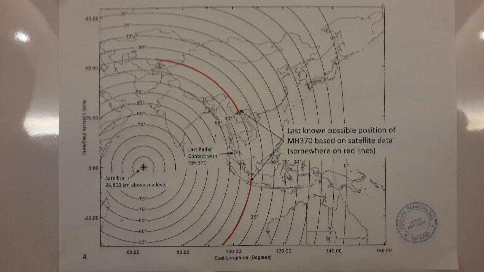
Seems like these corridors come from communication with a satellite and its clearance of the horizon. Although I can't make out with satellite it's supposed to be. Something in geostationary orbit, yeah. But ~64° E? There are two Intelsats at 68.5° E but not at 60°-65°.:hmm:
Upper corridor looks like a trip to Baikonur through Chinese airspace, lower one looks like a trip towards...the ocean floor.
Also a nice infographic by the Washington Post: How far MH370 could have gone.
If we follow the corridors that would be the ocean floor in the Southern Indian Ocean or the former Soviet republics in Asia and China.
Conspiracy theories about China's role in the search and them portraying Malaysia as incompetent in 3...2...1...
The official map by the Malaysian officials:
Seems like these corridors come from communication with a satellite and its clearance of the horizon. Although I can't make out with satellite it's supposed to be. Something in geostationary orbit, yeah. But ~64° E? There are two Intelsats at 68.5° E but not at 60°-65°.:hmm:
Upper corridor looks like a trip to Baikonur through Chinese airspace, lower one looks like a trip towards...the ocean floor.
Also a nice infographic by the Washington Post: How far MH370 could have gone.
If we follow the corridors that would be the ocean floor in the Southern Indian Ocean or the former Soviet republics in Asia and China.
Conspiracy theories about China's role in the search and them portraying Malaysia as incompetent in 3...2...1...
Inmarsat (probably Inmarsat-4 F1) - frequently used by airplanes for SATCOM uses.
If this was a criminal act as the transponder switch-offs suggest, how could they cope with 200+ passengers?
I was thinking of Helios 522, an accidental depressurization, but the plane flew on autopilot until fuel was exhausted. Someone with nefarious motives could strap on oxygen, flip a few switches to depressurize the cabin (early morning, everyone sleepy anyway), and perhaps climb as high as possible (MH370 is said to have achieved 45,000 ft), mischief managed. If they had the know-how to disable all these transponder systems, this would have been easy. Nobody awake to answer ringing cell phones in the plane, either.
This isn't painting a good picture for at least one member of the cockpit crew.
Inmarsat (probably Inmarsat-4 F1) - frequently used by airplanes for SATCOM uses.
Correction
") : Inmarsat-3 F1, the -4 is at 143.5° east.
: Inmarsat-3 F1, the -4 is at 143.5° east.- Joined
- Feb 6, 2008
- Messages
- 38,965
- Reaction score
- 3,937
- Points
- 203
- Location
- Wolfsburg
- Preferred Pronouns
- Sire
The data is from the pings of the SATCOM antenna system, which is pretty self-contained. You can seperate the communication system from using it, but the SATCOM will still keep on looking for the satellites and send such information in the administrative messages.
About the passengers: After 9/11 the cockpit doors had been made nearly impossible to penetrate by force. They could just sit and wait.
But the plot could also mean that the aircraft did not get that far but ended over the Indian ocean.
About the passengers: After 9/11 the cockpit doors had been made nearly impossible to penetrate by force. They could just sit and wait.
But the plot could also mean that the aircraft did not get that far but ended over the Indian ocean.
- Joined
- Mar 31, 2012
- Messages
- 2,298
- Reaction score
- 4
- Points
- 0
Warships & satellites control that area closely, and piracy has been significantly reduced in that essential area. Well, they can have spotted the plane and not tell anything yet, that's a possibility.
Switch the transponder on and fly at the cruise attitude.
Even if some warship picks you up, nobody will think to match your transponder code to that of the plane lost on the other side of the world.
---------- Post added at 12:54 PM ---------- Previous post was at 12:04 PM ----------
Upper corridor looks like a trip to Baikonur through Chinese airspace,
Which makes no sense, because they were going to China in the first place.
lower one looks like a trip towards...the ocean floor.
Note that this is the last known position. It does not means that the red line is the is the path of the a/c -- it means that the last known position of the a/c is somewhere on the red line. This map tells you where the a/c was when it finally disappeared, not how it got there.
So the northern line can be ruled out I think; too many military radars.
But on the south, the red circle seems to be close to Cocos Islands. Further SW along the same route you have French Southern & Antarctic Land and Heard Island.
I don't think that someone wanted to steal the plane to repeat 9/11. A plane flying into a country's airspace without a pre-filed flight plan is going to get intercepted immediately. I think the plane was stolen because of its cargo.
But if I was after something that was on the plane, I wouldn't fly to some island in the middle of the ocean, because it would be difficult to get the cargo off the island. I would fly to a large landmass. My initial guess was East Africa. Land in a pre-agreed location in the middle of the desert, transfer cargo to the truck and drive away, abandoning pax to their own fate.
But that map would point to something more clever. Escape from Malaysia to the West, go out to the ocean outside the radar range, so any possible pursuit will think you're going to Africa, then turn south and fly to Western Australia, keeping south of Indonesia. Much better location for cargo handover than Somalia, no armed mercenary bands and you can actually get to civilization by truck in a few days.
Except that it seems that the a/c did not make it to Western Australia. If the hijackers could switch off ACARS, they would have done so right away. So I think it crashed into the ocean somewhere on the lower red line.
The most logical thing is that the pax have figured out what's going on and stormed the cockpit. I mean, if you are still over the ocean when you were supposed to be over the land for hours... Yes, the doors have been reinforced, but no doors are going to survive several hours of repeated, persistent ramming with the duty-free tray.
That, or someone has shot that airplane down near the coast of Austrialia but is keeping his mouth shut.
---------- Post added at 04:03 PM ---------- Previous post was at 12:54 PM ----------
Satellite transmission data analyzed by U.S. investigators showed that the Malaysian Airline (MAS) System Bhd. jetliner’s most likely last-known position was in a zone about 1,000 miles (1,609 kilometers) west of Perth, Australia, said two people in the U.S. government who are familiar with the readings. Najib was told that is the most promising lead on locating the plane, one of the people said.
http://www.bloomberg.com/news/2014-...rch-zone-as-flight-deliberately-diverted.html
---------- Post added at 04:10 PM ---------- Previous post was at 04:03 PM ----------
That does not look good for Malaysian military:
in the early morning hours of March 8, the four-person crew watching for intrusions into the country’s airspace either did not notice or failed to report a blip on their defensive radar and air traffic radar that was moving steadily across the country from east to west, heading right toward them, said the person with knowledge of the matter.
Neither that team nor the crews at two other radar installations at Kota Bharu, closer to where the airliner last had contact with the ground, designated the blip as an unknown intruder warranting attention, the person said. The aircraft proceeded to fly across the country and out to sea without anyone on watch telling a superior and alerting the national defense command near Kuala Lumpur, even though the radar contact’s flight path did not correspond to any filed flight plan.
http://www.nytimes.com/2014/03/16/w...plicating-the-task-of-finding-flight-370.html
Switch the transponder on and fly at the cruise attitude.
Even if some warship picks you up, nobody will think to match your transponder code to that of the plane lost on the other side of the world.
I don't agree. Modern radar systems have recorders, and those would certainly have been analyzed.
Again, in the whole middle of the Indian Ocean sits Diego Garcia, a huge US military naval base notably used for aircraft carriers maintenance. If a place has good long-range military radars, that's this one.
So we can assume the plane didn't flew over there, which reinforces the southern path theory.
Far in the South are the French Southern and Antartic Land. Those islands are small, the climate is cold and windy, and are basically ancient volcanoes getting out of the sea. Not a place to land a jet. Still, there is :
Saint-Paul & New-Amsterdam islands : 2 islands. 66 km². 20 permanent inhabitants. There's not even enough room for a runway strip.
Kerguelen islands : more than 300 "islands". Some barely more than reefs. 7215 km². 45 inhabitants, all located in Port-aux-Français, a logistic, surveillance and scientific outpost. Daunting cracked terrain with fjords everywhere. Mount Ross culminates at 1850 meters over Grande-Terre, the main island. The ideal place if I had to hide a nuclear submarine. But not a plane.
Crozet islands : 5 islands, and some reefs. 352 km². 23 inhabitants. Volcanic terrain again. Average temperature : 5°C. Winds are very often over 100 km/h. Not a suitable place to land a jet.
South of Kerguelen islands, you have the Australian Heart & McDonald islands. 372 km² of volcanic, icy terrain. No inhabitants.
West of the Crozet islands are the Prince Edward islands, owned by South Africa. 2 islands, 335 km² of volcanic terrain, only visited by scientific teams from time to time. Again, nothing to do with a jet here.
BTW, southwards lies Antartica. I wonder if you could find a plain of ice long enough to land an airliner. But I don't see the point at all, you can't expect to survive a long time there.

And here's a map of all the 634 runways long enough (5,000 feet) to theorically allow MAF-370 to land, and located in a 2,200 nm radius :

Last edited:
Sky Captain
New member
- Joined
- Jan 29, 2009
- Messages
- 945
- Reaction score
- 0
- Points
- 0
This gets stranger and stranger. Currently I think most likely scenario is the plane was hijacked and then crashed somewhere in the ocean because it ran out of fuel or passengers broke into cockpit and started to fight with hijackers.
I fail to see how it could possibly landed somewhere and remained hidden. I bet all possible airfields where 777 could land has been checked on satellite images. Besides a 777 landing in some place normally used by small bush aircraft would generate lot of attention and even in third world country someone would have snapped a photo with mobile phone and posted on Internet.
I fail to see how it could possibly landed somewhere and remained hidden. I bet all possible airfields where 777 could land has been checked on satellite images. Besides a 777 landing in some place normally used by small bush aircraft would generate lot of attention and even in third world country someone would have snapped a photo with mobile phone and posted on Internet.
- Joined
- Sep 12, 2010
- Messages
- 3,133
- Reaction score
- 415
- Points
- 123
- Location
- Rome
- Website
- www.tuttovola.org
Could it ever be possible?...Besides a 777 landing in some place normally used by small bush aircraft would generate lot of attention...
I mean, a bush-pilot landing strip would most surely mean a crash for a 777...gear failure or similar...
- Joined
- Feb 6, 2008
- Messages
- 38,965
- Reaction score
- 3,937
- Points
- 203
- Location
- Wolfsburg
- Preferred Pronouns
- Sire
Could it ever be possible?
I mean, a bush-pilot landing strip would most surely mean a crash for a 777...gear failure or similar...
And some more failures that follow. A dirt strip would not withstand the ground pressure. A glacier, like the Antarctic would also not work. This looks like a smooth surface from above, but in reality, you have a rough surface with deep gaps, that is only covered by snow. Would likely be better than the dirt strip for keeping the plane mostly intact, since the ice would for a short moment act like it is hard as steel. But being stranded in the antarctic is a pretty bad idea.
- Joined
- Jan 7, 2008
- Messages
- 5,814
- Reaction score
- 869
- Points
- 203
- Location
- Earth
- Website
- orbides.org
- Preferred Pronouns
- she/her
Unless the hijacker was insane... Wanted to join the secret antarctic nazi party or something.But being stranded in the antarctic is a pretty bad idea.
On a serious note - what determines if military disclose the location of the plane in case it was tracked by their radars all that time?
USA and Australian forces are likely candidates.
Sky Captain
New member
- Joined
- Jan 29, 2009
- Messages
- 945
- Reaction score
- 0
- Points
- 0
Could it ever be possible?
I mean, a bush-pilot landing strip would most surely mean a crash for a 777...gear failure or similar...
If the hijackers wanted only some cargo or person onboard a survivable crash landing may be acceptable.
An abandoned WW II or Vietnam war era US airforce base may have runway long and strong enough to support 777 landing and takeoff however I bet such places were checked as soon as it become suspected plane may be hijacked.