Updates LRO/LCROSS News and Updates

orb

New member
News Reporter
Joined
Oct 30, 2009
Messages
14,020
Reaction score
4
Points
0
NASA:
NASA Spacecraft Reveals Recent Geological Activity on the Moon

Feb. 20, 2012

New images from NASA's Lunar Reconnaissance Orbiter (LRO) spacecraft show the moon's crust is being stretched, forming minute valleys in a few small areas on the lunar surface. Scientists propose this geologic activity occurred less than 50 million years ago, which is considered recent compared to the moon's age of more than 4.5 billion years.

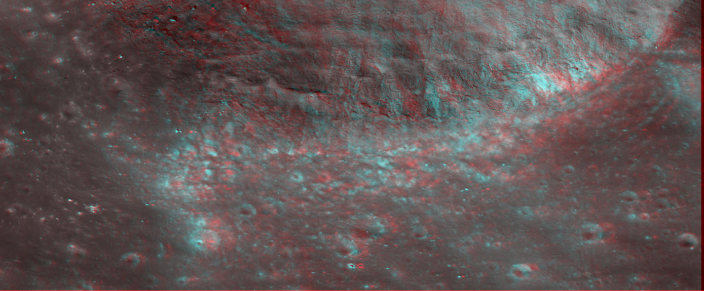
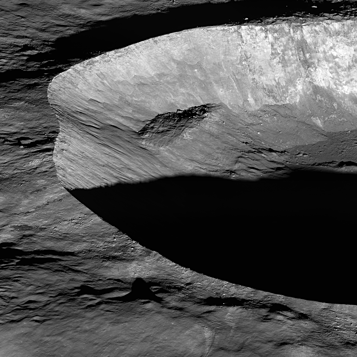
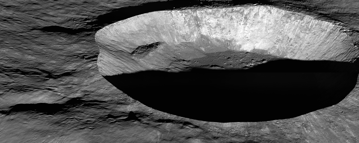
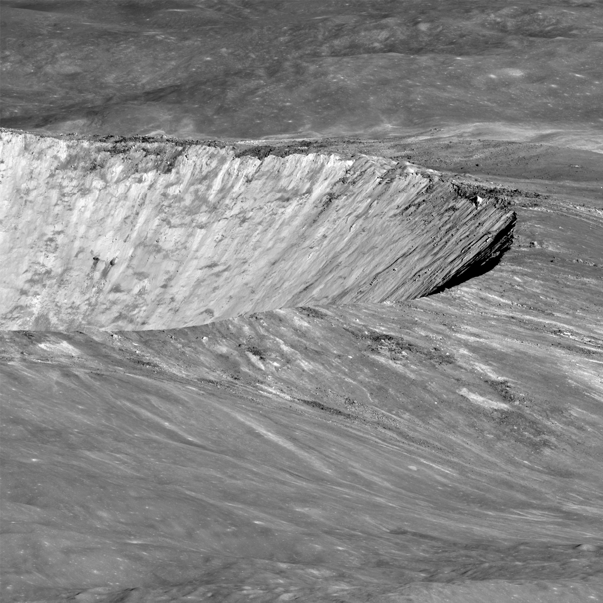
A team of researchers analyzing high-resolution images obtained by the Lunar Reconnaissance Orbiter Camera (LROC) show small, narrow trenches typically much longer than they are wide. This indicates the lunar crust is being pulled apart at these locations. These linear valleys, known as graben, form when the moon's crust stretches, breaks and drops down along two bounding faults. A handful of these graben systems have been found across the lunar surface.


"We think the moon is in a general state of global contraction because of cooling of a still hot interior," said Thomas Watters of the Center for Earth and Planetary Studies at the Smithsonian's National Air and Space Museum in Washington, and lead author of a paper on this research appearing in the March issue of the journal Nature Geoscience. "The graben tell us forces acting to shrink the moon were overcome in places by forces acting to pull it apart. This means the contractional forces shrinking the moon cannot be large, or the small graben might never form."

{colsp=2}
Click on images to enlarge​
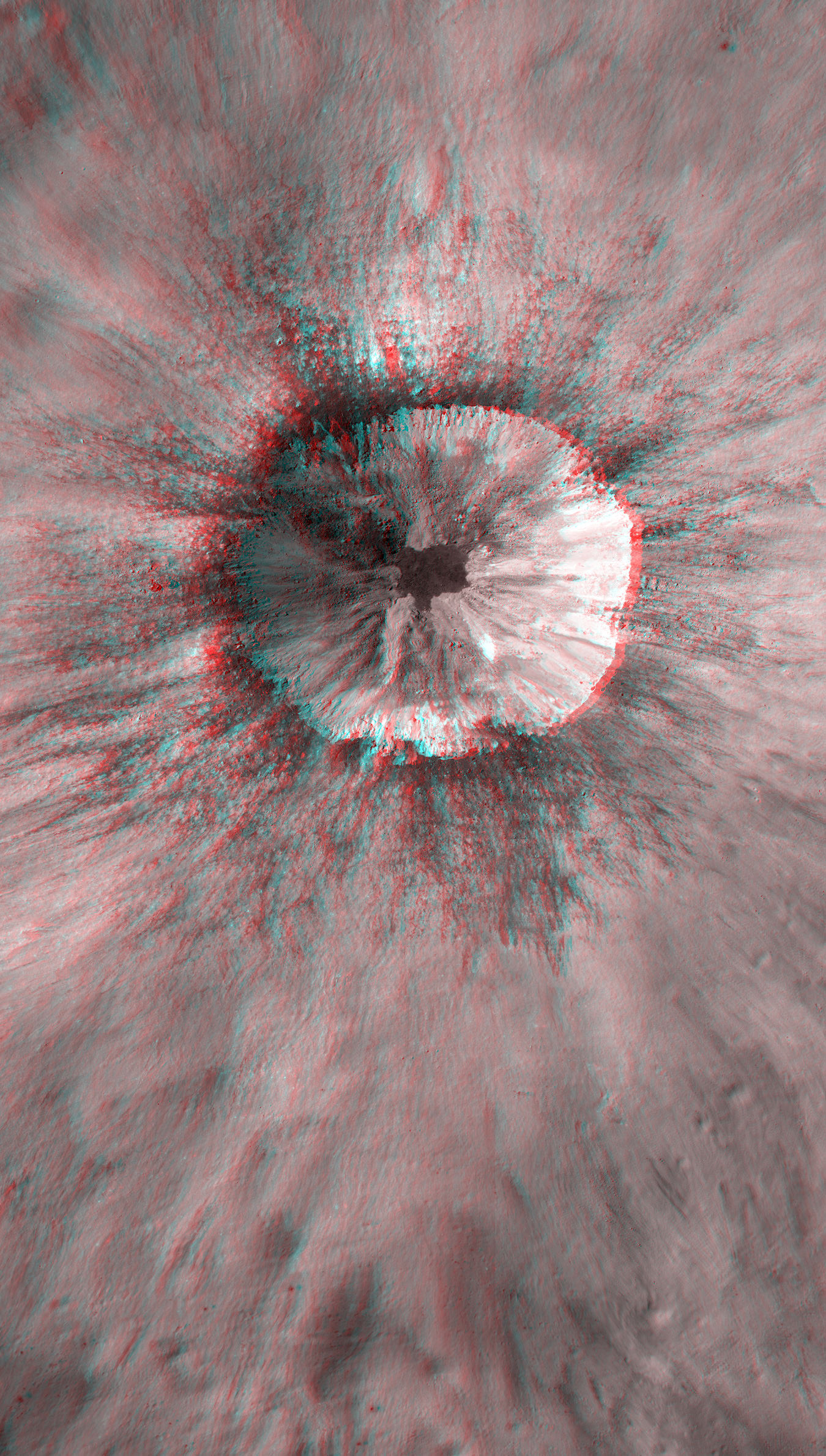
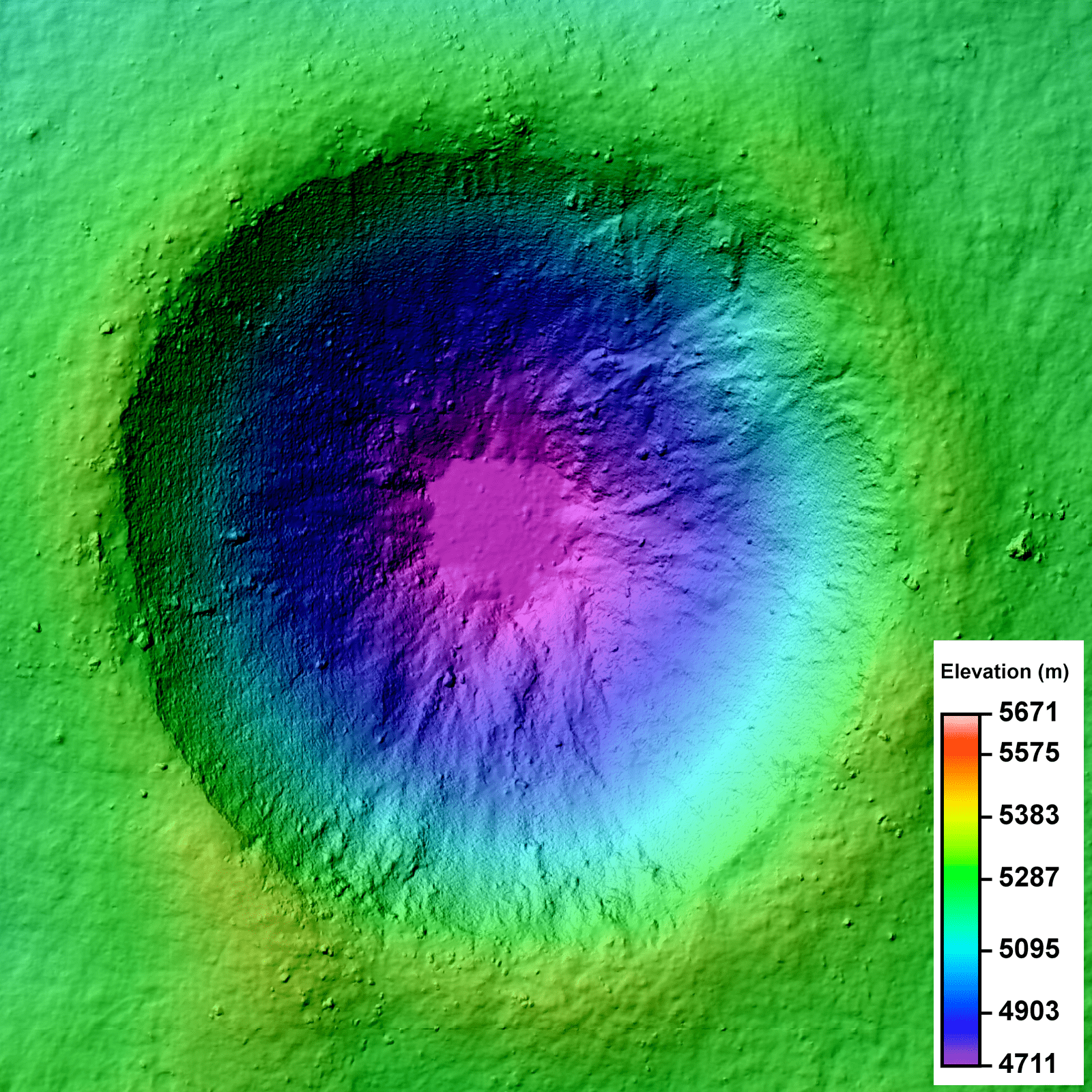
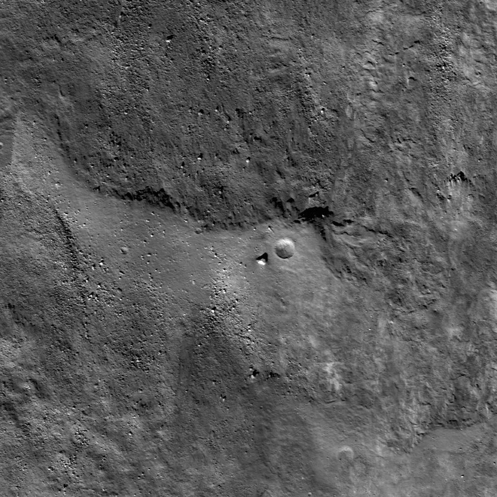
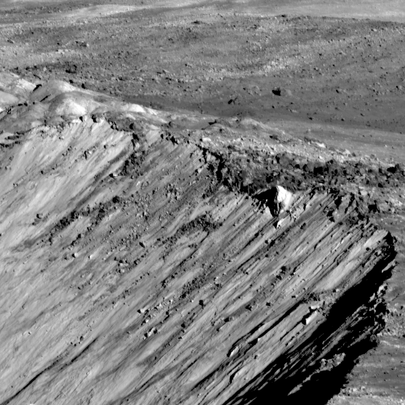
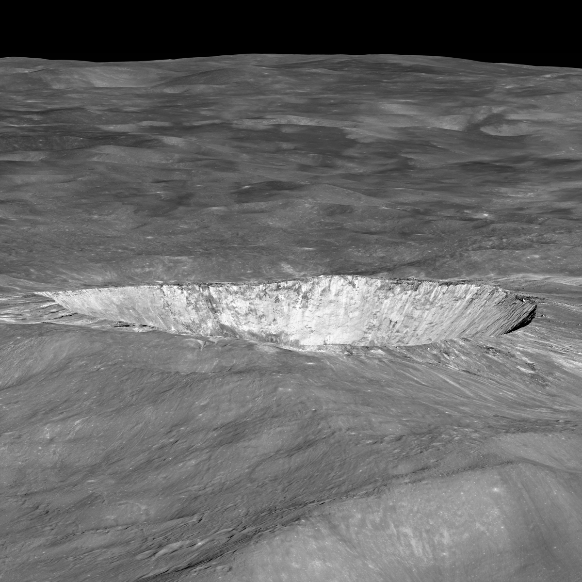
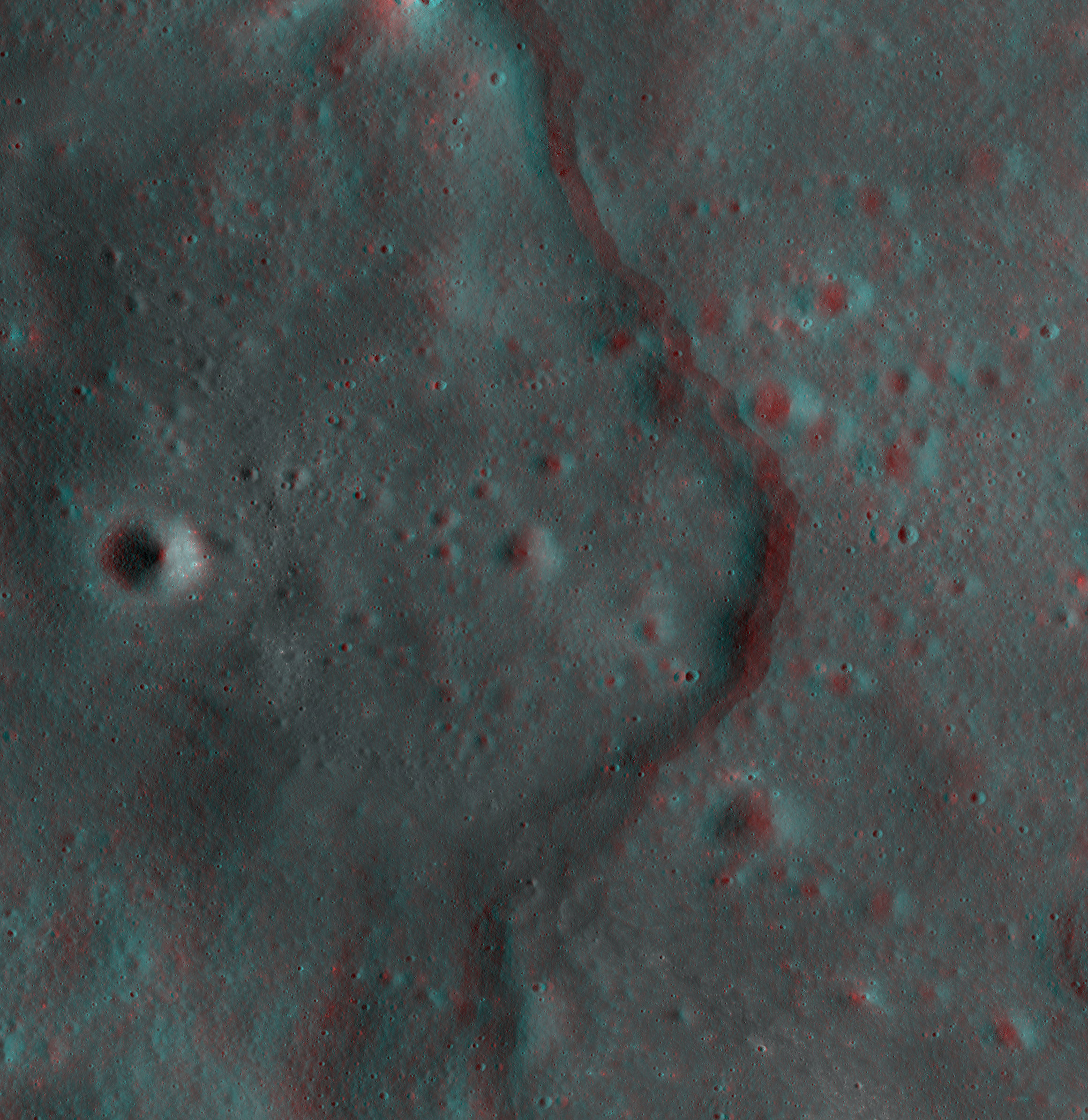
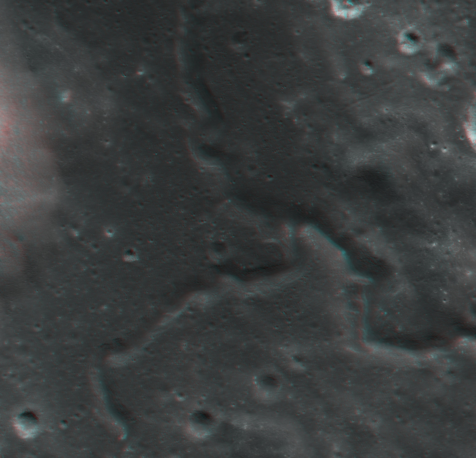
| This shows the largest of the newly detected graben found in highlands of the lunar farside. The broadest graben is about 500 meters (1,640 feet) wide and topography derived from Lunar Reconnaissance Orbiter Camera (LROC) Narrow Angle Camera (NAC) stereo images indicates they are almost 20 meters (almost 66 feet) deep.
Credit: NASA/Goddard/Arizona State University/Smithsonian Institution​
| Graben are troughs formed when the lunar crust was stretched and pulled apart. This stretching causes the near-surface materials to break along two parallel normal faults, the terrain in between the twin faults drops down forming a valley.
Credit: Arizona State University/Smithsonian Institution​


The weak contraction suggests that the moon, unlike the terrestrial planets, did not completely melt in the very early stages of its evolution. Rather, observations support an alternative view that only the moon's exterior initially melted forming an ocean of molten rock.

In August 2010, the team used LROC images to identify physical signs of contraction on the lunar surface, in the form of lobe-shaped cliffs known as lobate scarps. The scarps are evidence the moon shrank globally in the geologically recent past and might still be shrinking today. The team saw these scarps widely distributed across the moon and concluded it was shrinking as the interior slowly cooled.

Based on the size of the scarps, it is estimated that the distance between the moon's center and its surface shank by approximately 300 feet. The graben were an unexpected discovery and the images provide contradictory evidence that the regions of the lunar crust are also being pulled apart.

"This pulling apart tells us the moon is still active," said Richard Vondrak, LRO Project Scientist at NASA's Goddard Space Flight Center in Greenbelt, Md. "LRO gives us a detailed look at that process."

As the LRO mission progresses and coverage increases, scientists will have a better picture of how common these young graben are and what other types of tectonic features are nearby. The graben systems the team finds may help scientists refine the state of stress in the lunar crust.

"It was a big surprise when I spotted graben in the far side highlands," said co-author Mark Robinson of the School of Earth and Space Exploration at Arizona State University, principal investigator of LROC. "I immediately targeted the area for high-resolution stereo images so we could create a three-dimensional view of the graben. It's exciting when you discover something totally unexpected and only about half the lunar surface has been imaged in high resolution. There is much more of the moon to be explored."

{...}


NASA Goddard: NASA Spacecraft Reveals Recent Geological Activity on the Moon

NASA Press Release: RELEASE : 12-055 - NASA Spacecraft Reveals Recent Geological Activity on the Moon
 

orb

New member
News Reporter
Joined
Oct 30, 2009
Messages
14,020
Reaction score
4
Points
0
NASA:
Apollo 11: 'A Stark Beauty All Its Own'

Mar. 7, 2012

628459main_Apollo_11.jpg

This image of the Apollo 11 landing site captured from just 24 km (15 miles) above the surface provides LRO's best look yet at humanity’s first venture to another world. When Neil Armstrong took his famous first steps onto the lunar surface, he kicked around the soil. “Yes, the surface is fine and powdery.” Gazing at the flat horizon, he took in the view. “Isn’t that something! Magnificent sight out here.” After collecting a contingency sample Neil looked around and observed, "it has a stark beauty all its own. It's like much of the high desert of the United States. It's different, but it's very pretty out here." A few minutes later Buzz Aldrin descended the ladder and joined Neil on the surface of the Moon!

You can see the remnants of their first steps as dark regions around the Lunar Module (LM) and in dark tracks that lead to the scientific experiments the astronauts set up on the surface. The Passive Seismic Experiment Package (PSEP) provided the first lunar seismic data, returning data for three weeks after the astronauts left, and the Laser Ranging RetroReflector (LRRR) allows precise measurements to be collected to this day. You can even spot the discarded cover of the LRRR.

Another trail leads toward Little West crater around 50 meters (164 feet) to the east of the LM. This was an unplanned excursion near the end of the two and a half hours spent on the surface. Armstrong ran over to get a look inside the crater, and this was the farthest either astronaut ventured from the landing site. Compared to Apollo 12 and 14, which allowed for more time on the surface, and Apollo 15, 16, and 17, which had the benefit of a Lunar Roving Vehicle, Armstrong and Aldrin's surface activities were quite restricted. Their tracks cover less area than a typical city block!

628460main_a11pan.jpg

Not only was the landscape a place of "stark beauty", but also the source of rocks that revealed the Moon’s fiery past for the first time. The samples showed that the Apollo 11 landing site in Mare Tranquillitatis was once the site of volcanic activity, and the flat surface that afforded such an incredible vista was due to broad, thin flows of lava that flooded the region.

More from Arizona State University's LRO Camera's website
 

orb

New member
News Reporter
Joined
Oct 30, 2009
Messages
14,020
Reaction score
4
Points
0
NASA:
Apollo 16: What Young Really Means on the Moon

Mar. 8, 2012

628578main_M175179080LR_thumb.jpg

Area on the southeastern rim of North Ray crater, explored by Apollo 16 astronauts John Young and Charlie Duke, revealed in a new low-altitude image. Area shown is 300 meters wide, black arrows show foot tracks. (NAC Image M175179080L,R) Image credit: NASA Goddard/Arizona State University

One of the main goals of the Apollo 16 mission was to explore and sample a young bright-rayed crater aptly named North Ray crater (890 m diameter). Its high reflectivity is due to its young age.

During an impact event, geologic material is excavated and spread around a crater. The deepest material ends up near the rim, and shallower material is thrown farther. The pre-existing surface was mature, meaning that its brightness or albedo was diminished over time due to solar wind and micrometeorite bombardment (space weathering). The fresh material had not suffered these effects, thus its high albedo.

This space weathering process takes hundreds of millions of years to complete. At the the time of the Apollo 16 mission scientists did not know the age of North Ray crater, nor did they know as much as we know today about the details of the space weathering process, so an important goal was to learn what young really means on the Moon.

Visit Arizona State University's LRO Camera website for more information and images
 

orb

New member
News Reporter
Joined
Oct 30, 2009
Messages
14,020
Reaction score
4
Points
0
NASA:
Two New NASA LRO Videos: See Moon's Evolution, Take a Tour

Mar. 14, 2012

In honor of 1,000 days in orbit, the NASA Lunar Reconnaissance Orbiter (LRO) team at NASA Goddard Space Flight Center in Greenbelt Md. has released two new videos.

One video takes viewers through the moon's evolutionary history, and reveals how it came to appear the way it does today. Another video gives viewers a guided tour of prominent locations on the moon's surface, compiled by the spacecraft's observations of the moon.

"Evolution of the Moon" explains why the moon did not always look like it does now. The moon likely started as a giant ball of magma formed from the remains of a collision by a Mars sized object with the Earth about four and a half billion years ago. After the magma cooled, the moon's crust formed. Then between 4.5 and 4.3 billion years ago, a giant object hit near the moon's South Pole, forming the South Pole-Aitken Basin, one of the two largest proven impact basins in the solar system. This marked the beginning of collisions that would cause large scale changes to the moon's surface, such as the formation of large basins.

Because the moon had not entirely cooled on the inside, magma began to seep through cracks caused by impacts. Around one billion years ago, it's thought that volcanic activity ended on the near side of the moon as the last of the large impacts made their mark on the surface. The moon continued to be battered by smaller impacts. Some of the best-known impacts from this period include the Tycho, Copernicus, and Aristarchus craters. So, while the moon today may seem to be an unchanging world, its appearance is the result of billions of years of violent activity.

The two-and-a-half minute video is available for viewing and downloading at: http://svs.gsfc.nasa.gov/goto?10930


"Tour of the Moon" takes viewers to several interesting locations on the moon. Tour stops included in this breathtaking journey across the moon's surface are: Orientale Basin, Shackleton crater, South Pole-Aitken Basin, Tycho crater, Aristarchus Plateau, Mare Serenitatis, Compton-Belkovich volcano, Jackson crater and Tsiolkovsky crater. The fully narrated video, as well as clips from each of the stops on the tour, are available to everyone in formats viewable on virtually any device.

To view the whole tour; go to: http://svs.gsfc.nasa.gov/goto?10929

{...}
 

orb

New member
News Reporter
Joined
Oct 30, 2009
Messages
14,020
Reaction score
4
Points
0
SPACE.com: Cosmic Rays Bombing the Moon Transform Lunar Surface:
Cosmic rays from beyond our solar system constantly pummel Earth's moon, fundamentally changing the chemistry and color of the lunar surface, scientists say.

Now, new measurements of the strength of this space radiation from NASA's Lunar Reconnaissance Orbiter show that these cosmic rays can cause significant chemical alteration on the surface of the moon. The measurements also help scientists test theoretical models of the moon's radiation environment.

{...}

The new findings are especially useful because the Lunar Reconnaissance Orbiter's CRaTER instrument, which the researchers used in the new study, measures how much radiation pierces a layer of plastic designed to simulate human tissue, thus revealing how much radiation would likely pass through astronauts' bodies.

Furthermore, the measurements were made during a period of especially heavy cosmic ray radiation, because the sun happened to be experiencing a lull in activity, which otherwise would have damped down on cosmic rays.

{...}

Universe Today: New Data Find a Silver Lining of Cosmic Radiation
 

orb

New member
News Reporter
Joined
Oct 30, 2009
Messages
14,020
Reaction score
4
Points
0
LROC: 1000 Day Anniversary of LROC Imaging:
Today marks the one thousand day anniversary of LROC imaging from lunar orbit. Since 30 June 2009, LROC has acquired a total of 750,000 images: of these, 140,000 are WAC images and 440,000 are NAC images of the illuminated Moon (the remainder are night or space calibration images). So far the NACs have imaged about 40% of the Moon. NAC and WAC images will play a key role defining where human and robotic explorers will go to unravel many remaining mysteries of the Moon and inner Solar System.

{...}
 

orb

New member
News Reporter
Joined
Oct 30, 2009
Messages
14,020
Reaction score
4
Points
0
NASA:
NASA's Lunar Reconnaissance Orbiter Brings 'Earthrise' to Everyone

Everyone can see an Earthrise in this new NASA visualization, which draws on richly detailed maps of the moon's surface made from data gathered by NASA's Lunar Reconnaissance Orbiter.
Credit: NASA/GSFC​

Imagine yourself in orbit, your spacecraft flying backward with its small window facing down toward the surface of the moon. You peer out, scouring the ash-colored contours of the cratered landscape for traces of ancient volcanic activity. Around you, the silent, velvety blackness of space stretches out in every direction.

The spacecraft rolls over, and you glimpse a sliver of intense light starting to climb over the rough horizon. It might be dawn, except that the bright sliver quickly morphs into an arc of dazzling white swirled with vivid blue and then rises far enough to be recognized as the brilliant, marbled Earth. Captured on film, this breathtaking view becomes the iconic photograph "Earthrise."

On December 24, 1968, three people saw this happen firsthand: Apollo 8 Commander Frank Borman and crew members William A. Anders and James A. Lovell, Jr. Now, in honor of Earth Day 2012, the rest of us can see what that was like in a new NASA visualization, which draws on richly detailed maps of the moon's surface made from data gathered by NASA's Lunar Reconnaissance Orbiter (LRO).

"This visualization recreates for everyone the wondrous experience of seeing Earth from that privileged viewpoint," says LRO Project Scientist Rich Vondrak of NASA's Goddard Space Flight Center in Greenbelt, Md.

At the time of the famous photo, Apollo 8 was rounding the moon for the fourth time, traveling in a nearly circular orbit about 110 kilometers (68 miles) above the moon's surface at about a mile per second. "The spacecraft was pointed down to look at the moon's surface, because Anders was conducting an extensive photographic survey," explains James Rice, an astrogeologist at Goddard. "But Lovell needed to perform a navigation sighting, so Borman rolled the spacecraft." That's when Earth abruptly appeared.

To recreate this scene, NASA animator Ernie Wright reconstructed the orbit in software, using coordinates from an Apollo 8 mission report and photographs taken by the crew. "Apollo 8 was at 11 degrees south latitude and between 118 and 114 east longitude, with a westward view," says Wright. "The floor of Pasteur crater is visible in the foreground of the photograph."

Wright rendered the crisp contours of the moonscape using high-resolution topography data from LRO's Lunar Orbiter Laser Altimeter, which has provided the most precise and complete maps to date of the moon's complex, heavily cratered terrain.

The Earth shown in the visualization is not an exact duplication of what the astronauts saw but a mosaic of more recent images taken by the Moderate Resolution Imaging Spectroradiometer (known as MODIS) instrument on the Terra satellite and assembled by NASA's Visible Earth team.

The narration in the visualization comes from the original audio recording of the Apollo 8 astronauts, their commentary on the task at hand interrupted as they react to the sudden sighting of Earth. "Oh my God!" an astronaut calls out. "Look at that picture over there!"

{colsp=2}
Click on images to enlarge​
| The renowned "Earthrise" image is the first color image of our planet taken from space.
Credit: NASA​
| Earthrise in black and white, the first picture of Earth taken by a human in orbit around the moon, is presented with the horizon oriented vertically because that is how the astronauts described seeing it.
Credit: NASA​


A black-and-white image is snapped with one of the Hasselblad cameras on board, capturing the very first picture of Earth taken by a human in orbit around the moon. The crew then scrambles to get a color picture, which is taken 58 seconds after the black-and-white photo.

The color image, which simultaneously captures Earth's bold vitality and its fragility, is later named "Earthrise" and has been reproduced countless times, including a U.S. postage stamp issued on May 5, 1969. This popularity earned the photo the featured spot on the cover of Life's book "100 Photographs that Changed the World," in which wilderness photographer Galen Rowell deemed it "the most influential environmental photograph ever taken."

{...}
 

orb

New member
News Reporter
Joined
Oct 30, 2009
Messages
14,020
Reaction score
4
Points
0
Universe Today: Moon Craters 3-D!

unnamed_crater_3d_by_nathanial_bb-d4yfak8.jpg

A young unnamed crater on the Moon west of Isaev crater. Credit: NASA/GSFC/Arizona State University; Anaglyph by Nathanial Burton-Bradford.


NAC_DTM_FRESH1_COLOR_thumb.png

Digital Terrain Model (DTM) of an unnamed crater in the farside highlands. Image is 3.2 km across. Credit: NASA/GSFC/Arizona State University.


3d_impact_melt__crater_rim_near_side_by_nathanial_bb-d4yj6l4.jpg

3D anaglyph of rim impact melt deposit on Unnamed crater on nearside highlands (38.112°N, 53.052°E; northeast of Mare Tranquillitatis). Credit: NASA/GSFC/Arizona State University; anaglyph by Nathanial Burton-Bradford.


M170205366LE_new.png

Impact melt started to flow back into the crater cavity before it solidified. Image width is 500 m, from the LROC Narrow Angle Camera. Credit: NASA/GSFC/Arizona State University.​
 

orb

New member
News Reporter
Joined
Oct 30, 2009
Messages
14,020
Reaction score
4
Points
0
NASA:
Researchers Estimate Ice Content of Crater at Moon's South Pole

June 20, 2012

NASA's Lunar Reconnaissance Orbiter (LRO) spacecraft has returned data that indicate ice may make up as much as 22 percent of the surface material in a crater located on the moon's south pole.

The team of NASA and university scientists using laser light from LRO's laser altimeter examined the floor of Shackleton crater. They found the crater's floor is brighter than those of other nearby craters, which is consistent with the presence of small amounts of ice. This information will help researchers understand crater formation and study other uncharted areas of the moon. The findings are published in Thursday's edition of the journal Nature.

"The brightness measurements have been puzzling us since two summers ago," said Gregory Neumann of NASA's Goddard Space Flight Center in Greenbelt, Md., a co-author on the paper. "While the distribution of brightness was not exactly what we had expected, practically every measurement related to ice and other volatile compounds on the moon is surprising, given the cosmically cold temperatures inside its polar craters."

The spacecraft mapped Shackleton crater with unprecedented detail, using a laser to illuminate the crater's interior and measure its albedo or natural reflectance. The laser light measures to a depth comparable to its wavelength, or about a micron. That represents a millionth of a meter, or less than one ten-thousandth of an inch. The team also used the instrument to map the relief of the crater's terrain based on the time it took for laser light to bounce back from the moon's surface. The longer it took, the lower the terrain's elevation.

{colsp=2}
Click on images to enlarge​
| Elevation (left) and shaded relief (right) image of Shackleton, a 21-km-diameter (12.5-mile-diameter) permanently shadowed crater adjacent to the lunar south pole. The structure of the crater's interior was revealed by a digital elevation model constructed from over 5 million elevation measurements from the Lunar Orbiter Laser Altimeter.
Credit: NASA/Zuber, M.T. et al., Nature, 2012​
| This is an elevation map of Shackleton crater made using LRO Lunar Orbiter Laser Altimeter data. The false colors indicate height, with blue lowest and red/white highest.
Credit: NASA/Zuber, M.T. et al., Nature, 2012​


In addition to the possible evidence of ice, the group's map of Shackleton revealed a remarkably preserved crater that has remained relatively unscathed since its formation more than three billion years ago. The crater's floor is itself pocked with several small craters, which may have formed as part of the collision that created Shackleton.

The crater, named after the Antarctic explorer Ernest Shackleton, is two miles deep and more than 12 miles wide. Like several craters at the moon's south pole, the small tilt of the lunar spin axis means Shackleton crater's interior is permanently dark and therefore extremely cold.

"The crater's interior is extremely rugged," said Maria Zuber, the team's lead investigator from the Massachusetts Institute of Technology in Cambridge in Mass. "It would not be easy to crawl around in there."

While the crater's floor was relatively bright, Zuber and her colleagues observed that its walls were even brighter. The finding was at first puzzling. Scientists had thought that if ice were anywhere in a crater, it would be on the floor, where no direct sunlight penetrates. The upper walls of Shackleton crater are occasionally illuminated, which could evaporate any ice that accumulates. A theory offered by the team to explain the puzzle is that "moonquakes"-- seismic shaking brought on by meteorite impacts or gravitational tides from Earth -- may have caused Shackleton's walls to slough off older, darker soil, revealing newer, brighter soil underneath. Zuber's team's ultra-high-resolution map provides strong evidence for ice on both the crater's floor and walls.

"There may be multiple explanations for the observed brightness throughout the crater," said Zuber. "For example, newer material may be exposed along its walls, while ice may be mixed in with its floor."

The initial primary objective of LRO was to conduct investigations that prepare for future lunar exploration. Launched in June 2009, LRO completed its primary exploration mission and is now in its primary science mission. LRO was built and is managed by Goddard. This research was supported by NASA's Human Exploration and Operations Mission Directorate and Science Mission Directorate at the agency's headquarters in Washington.

{...}


NASA Press Release: RELEASE : 12-208 - NASA Spacecraft Reveals Ice Content in Moon Crater

MIT News: Researchers find evidence of ice content at the moon’s south pole

Universe Today: Loads of Ice Waiting for Explorers at the Moon’s Shackleton Crater

SPACE.com: Huge Moon Crater's Water Ice Supply Revealed

SpaceRef: Ice Found On The Moon's South Pole
 

orb

New member
News Reporter
Joined
Oct 30, 2009
Messages
14,020
Reaction score
4
Points
0
Universe Today: Barnstorming the Moon’s Giordano Bruno Crater

LROC: Very Oblique View of Giordano Bruno


M119245930LR_thumb.png

Southern rim of Giordano Bruno crater seen obliquely (79°) from 53 km altitude, small portion of NAC M119245930LR subsampled by a factor of three [NASA/GSFC/Arizona State University].


Rim_Detail.png

Full resolution detail of the steep inward dipping wall of Giordano Bruno [NASA/GSFC/Arizona State University].


M119245930LR_reduced.png

A wider, reduced resolution view of Giordano Bruno and its ejecta blanket. Click on the image above to enlarge, or below for a full resolution version of this image [NASA/GSFC/Arizona State University]​
 

orb

New member
News Reporter
Joined
Oct 30, 2009
Messages
14,020
Reaction score
4
Points
0
LROC: Question Answered!

SPACE.com: Apollo Moon Landing Flags Still Standing, Photos Reveal

Universe Today: Flags Still Standing at Several Apollo Landing Sites on the Moon

apollo-17-flag.png

Caption: LROC image showing the illuminated side of the still standing American flag to be captured at the Apollo 17 landing site. Credit: NASA/GSFC/Arizona State University.


apollo-16-flag-580x580.png

Caption: The flag was captured in this image of the Apollo 16 site with the spacecraft slewed 15° towards the Sun; the shadowed side of the flag is seen by LROC. Credit: NASA/GSFC/Arizona State University.


apollo-11-close-up.jpg

Caption: Enlargement of area surrounding Apollo 11 landing site. Credit: NASA/GSFC/Arizona State University​


collectSPACE: Beyond a shadow of a doubt: US flags still standing at Apollo moon landing sites

Discover Magazine - Bad Astronomy: … and the flags *ARE* still there!
 

orb

New member
News Reporter
Joined
Oct 30, 2009
Messages
14,020
Reaction score
4
Points
0
NASA:
Walls of Lunar Crater May Hold Patchy Ice, LRO Radar Finds

August 30, 2012

Small patches of ice could make up at most five to ten percent of material in walls of Shackleton crater.

Scientists using the Mini-RF radar on NASA's Lunar Reconnaissance Orbiter (LRO) have estimated the maximum amount of ice likely to be found inside a permanently shadowed lunar crater located near the moon's South Pole. As much as five to ten percent of material, by weight, could be patchy ice, according to the team of researchers led by Bradley Thomson at Boston University's Center for Remote Sensing, in Mass.

"These terrific results from the Mini-RF team contribute to the evolving story of water on the moon," says LRO's deputy project scientist, John Keller of NASA's Goddard Space Flight Center in Greenbelt, Md. "Several of the instruments on LRO have made unique contributions to this story, but only the radar penetrates beneath the surface to look for signatures of blocky ice deposits."

Click on image to enlarge​
Radar data indicate that the walls of Shackleton crater may hold ice. Actual observations (CPR) by LRO's Mini-RF instrument are compared to calculated radar values for 0.5% to 10% ice.
Credit: NASA​


These are the first orbital radar measurements of Shackleton crater, a high-priority target for future exploration. The observations indicate an enhanced radar polarization signature, which is consistent with the presence of small amounts of ice in the rough inner wall slopes of the crater. Thomson and his colleagues reported the findings in a paper recently published in the journal Geophysical Research Letters.

"The interior of this crater lies in permanent shadow and is a 'cold trap'—a place cold enough to permit ice to accumulate," says Mini-RF's principal investigator, Ben Bussey of the Johns Hopkins University Applied Physics Laboratory in Laurel, Md. "The radar results are consistent with the interior of Shackleton containing a few percent ice mixed into the dry lunar soil."

These findings support the long-recognized possibility that areas of permanent shadow inside polar impact craters are sites of the potential accumulation of water. Numerous lines of evidence from recent spacecraft observations have revised the view that the lunar surface is a completely dry, inhospitable landscape. Thin films of water and hydroxyl have been detected across the lunar surface using several space-borne near-infrared spectrometers. Additionally, orbital neutron measurements indicate elevated levels of near‐surface hydrogen in the polar regions; if in the form of water, this hydrogen would represent an average ice concentration of about 1.5% by weight in the polar regions.

The Shackleton findings are also consistent with those of the recent LCROSS spacecraft's controlled collision with a nearby permanently shadowed polar region near the lunar South Pole, which revealed evidence for water in the plume kicked up by its impact. A radar instrument flown on India's Chandrayaan-1 spacecraft in 2009 found evidence for ice deposits in craters at the lunar North Pole. Measurements of the albedo (surface reflectance) inside Shackleton crater using LRO's laser altimeter and far‐ultraviolet detector are also consistent with the presence of a small amount of ice.

"Inside the crater, we don't see evidence for glaciers like on Earth," says Thomson. "Glacial ice has a whopping radar signal, and these measurements reveal a much weaker signal consistent with rugged terrain and limited ice."

The radar measurements of Shackleton crater were made during three separate observations between December 2009 and June 2010. Radar illuminates shadowed regions and can detect deposits of water or ice, which have a distinctive radar polarization signature compared to the surrounding material. In addition, radar penetrates the terrain to depths of a meter or two and can measure water or ice buried beneath the surface. Radar measurements of Shackleton crater place an upper bound on the ice content of the uppermost meter of loose material of the crater's walls at between five and ten percent ice by weight.

"We are following up these tantalizing results with additional observations," says Bussey. "Mini-RF is currently acquiring new bistatic radar images of the moon using a signal transmitted by the Arecibo radio telescope in Puerto Rico. These bistatic images will help us distinguish between surface roughness and ice, providing further unique insights into the locations of volatile deposits."

{...}


SpaceRef: Water Ice in Shackleton Crater's Walls
 

orb

New member
News Reporter
Joined
Oct 30, 2009
Messages
14,020
Reaction score
4
Points
0
Universe Today: A New, Automatic 3-D Moon:
Who doesn’t love 3-D images, especially of objects in space? But creating them can be a bit time-consuming for scientists, especially for images from orbiting spacecraft like the Lunar Reconnaissance Orbiter that takes images from one angle at a time. Usually, it is “amateur” enthusiasts who take the time to find and combine images from different orbital passes to create rich, 3-D views.

But now, scientists at the University of Arizona and Arizona State University have developed a new automatic “brain” — a new automatic processing system that aligns and adjusts images from LRO, and combines them into images that can be viewed using standard red-cyan 3D glasses.

{...}

lroc_korolev_lobate_scarp.jpg

Korolev lobate scarp on the Moon, in 3-D. Lobate scarps, a type of cliff, ) on the Moon are found mostly in the highlands, and are relatively small and young.
Credit: NASA/GSFC/Arizona State University.


lroc_alpes_sinuous_rille.jpg

Alpes Sinuous Rille, an ancient channel formed as massive eruptions of very fluid lava poured across the surface of the Moon. Credit: NASA/GSFC/Arizona State University


lroc_orientale_sculpture.jpg

Ancient radial scars of ejecta extend out from the Orientale basin for hundreds of kilometers and consist of aligned craters and massive dune-like forms. They formed as streamers of lunar rock thrown out from the Orientale impact and crashed back to the surface. Credit: NASA/GSFC/Arizona State University​


SPACE.com: Amazing 3D Moon Photos Created from NASA Lunar Orbiter Imagery

NASA: Lunar Reconnaissance Orbiter Explores the Moon in 3-D
 
Top