Updates LRO/LCROSS News and Updates

orb

New member
News Reporter
Joined
Oct 30, 2009
Messages
14,020
Reaction score
4
Points
0
NASA LRO images:
July 25, 2011​
Farside Highlands Volcanism

Click on images to enlarge​
Small dome in the Compton-Belkovich region (61.33 °N, 99.68 °E). Evidence indicates a volcanic origin for this and other intriguing features in the region. Incidence angle is 64°, Sun is from the SSW, image is ~510 m across. NAC image number M139238146L.
[NASA/GSFC/Arizona State University]​
Same dome, lower Sun. The low Sun brings out small topographic features, note the summit boulder shadows. Image is 600 m on a side, NAC image number M119198897R.
[NASA/GSFC/Arizona State University]​


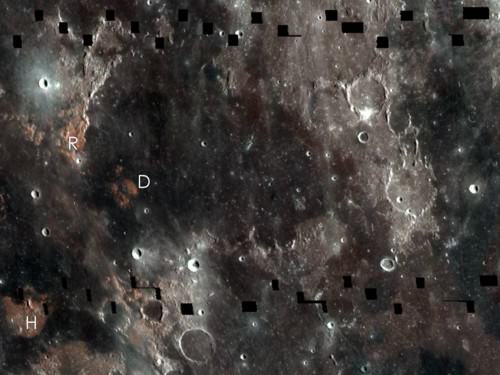
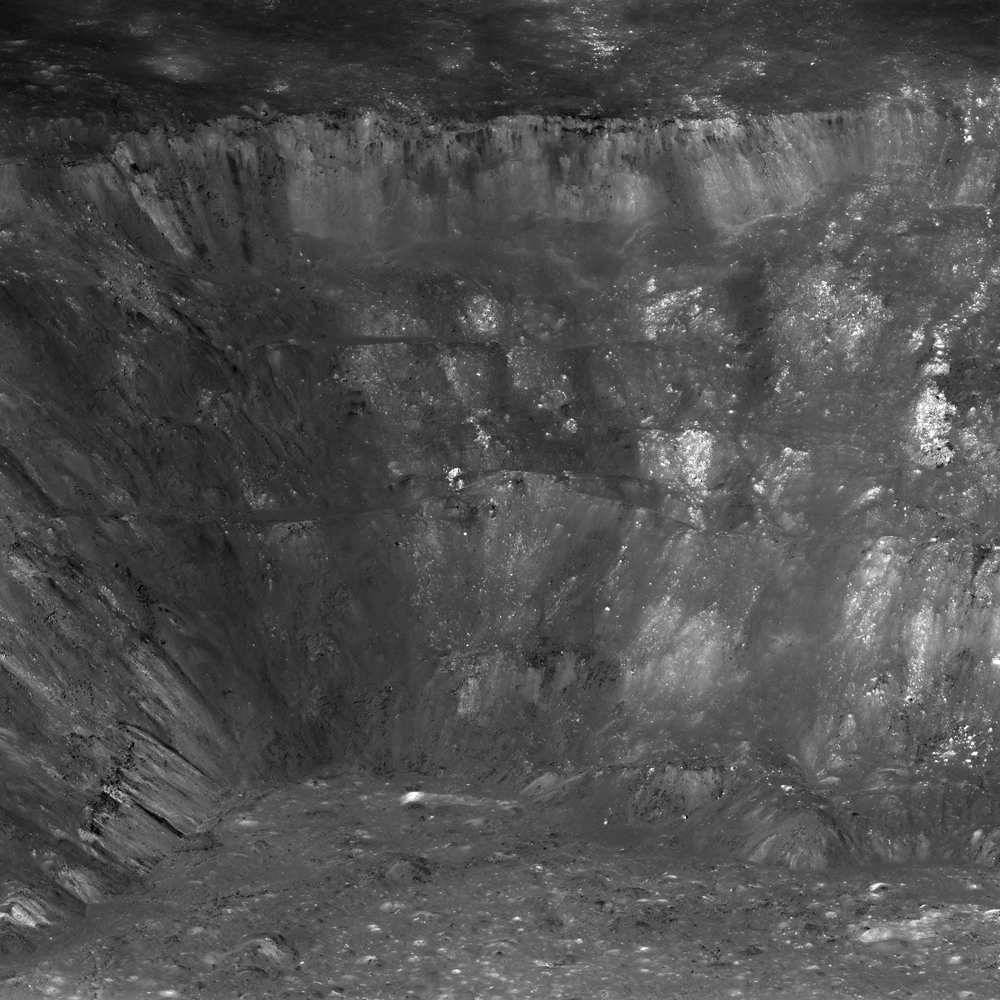
Since the domes in the Compton-Belkovich area are rounded and smooth (excepting the boulders scattered across the summit) they are not easy to spot. At sunrise and sunset (above) even smooth topography casts long shadows. In this case the Sun is 13° degrees above the horizon, showing that the slopes of the dome are steeper than 13°, an important clue to unraveling its origin. Steeper slopes often mean more viscous magma, which in turn points toward more silica rich compositions.

Click on image to enlarge​
Subsampled NAC image showing a wider view of dome and surroundings.
[NASA/GSFC/Arizona State University]​


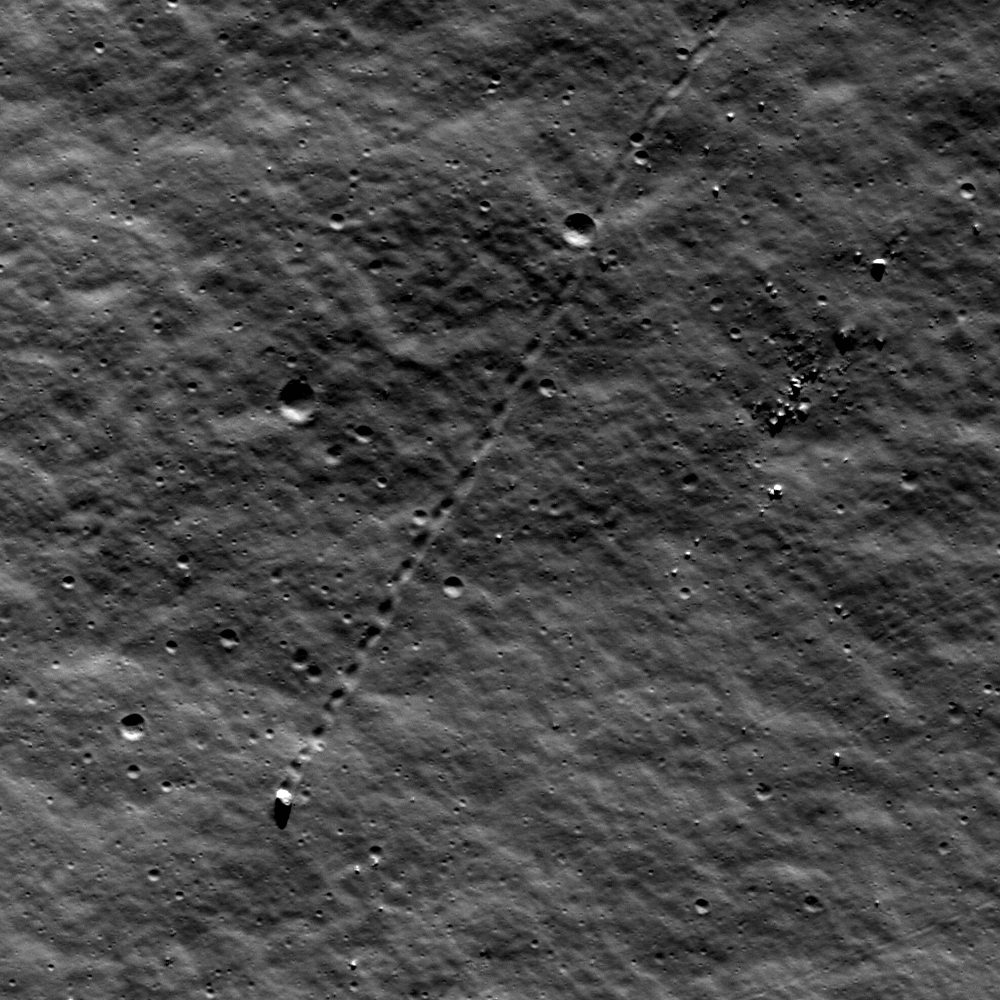
Are you having trouble seeing the feature as a dome, that is, with positive relief? Consider the above subsampled NAC image that shows a wider view and includes a small crater just east of the dome. The sun is from the left. Sometimes your brain can be fooled - you see what is up as what is down. If you know the Sun direction you can "force" the ups to become downs, and vice versa. And what about the little crater at the top of the dome? Is it a volcanic vent or an impact crater? If you said “impact crater” – you are right! The top of the dome is actually about 100 m south of the small crater. The crater just happens to be near the top of the dome.

Click on image to enlarge​
WAC mosaic showing the whole Compton-Belkovich region. The small dome and crater shown in the previous image are located at the tip of the arrow.


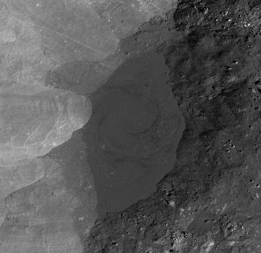
The Compton-Belkovich volcanic complex is easily spotted as the relatively bright area in the center-left side of the WAC mosaic (above), covering an area of about 35 km across. For scale, the distance between the longitude lines is about 15 km.

Click on image to enlarge​
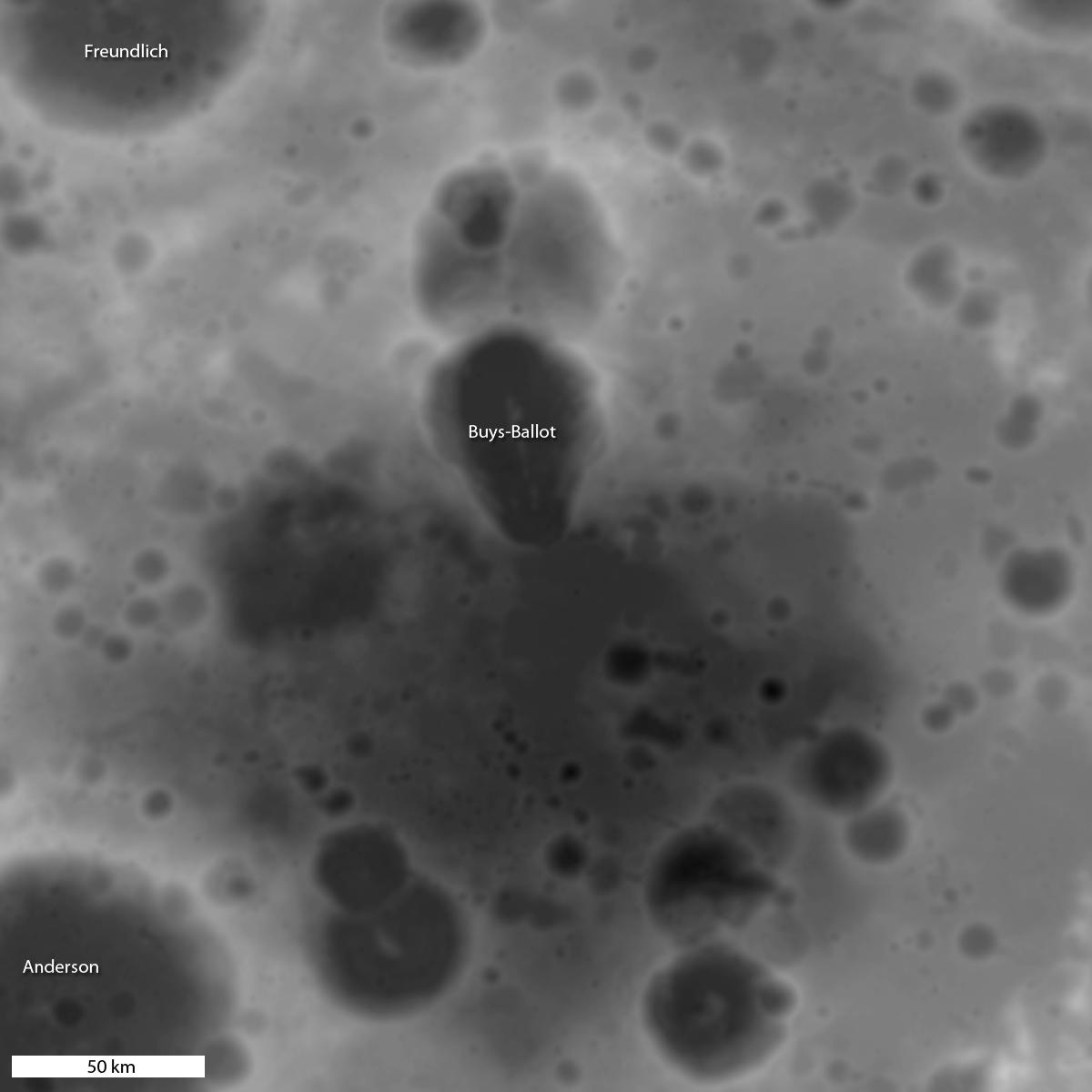
Composite image showing geochemistry from Lunar Prospector.
[Jolliff et al, 2011]​


The Compton-Belkovich site was of special interest even before the LRO mission began. Back in 1998 the Lunar Prospector spacecraft, with its gamma-ray spectrometer, measured the global distribution of the element thorium, which has a strong peak in the gamma-ray spectrum because it is naturally radioactive. Although much of the Moon’s thorium, at least as expressed on the surface, lies mostly on the nearside, a terrain between the craters Compton and Belkovich lit up like a bull’s eye (above).

This thorium “hot spot” was described by David Lawrence and the Lunar Prospector gamma-ray spectrometer team (see figure), later Jeff Gillis and coworkers noted in looking at Clementine images that a high albedo feature was located near the center of the thorium bull’s eye (see WAC context image above). However, since then, the origin of the hot spot and the nature of the deposits was not known until LRO imaged the site with the LROC Narrow Angle Cameras. Those images revealed numerous volcanic features, some large, and some small, like the little dome seen in today’s featured image. Between the Lunar Prospector and Diviner geochemistry and the LROC images, we are able to determine that these domes are examples of silicic (rich in silica relative to basalt) volcanism. An amazing discovery - the only silicic volcanism on the farside.

Full size images


SPACE.com: Rare Volcanoes Discovered On Far Side of the Moon:
Shielded from Earth-bound eyes, the far side of the moon is home to a rare set of dormant volcanoes that changed the face of the lunar surface, a new study finds.

Data and photos from NASA's Lunar Reconnaissance Orbiter (LRO) reveal the presence of now-dead silicate volcanoes, not the more common basaltic volcanoes that litter the moon's surface, researchers said.

"Most of the volcanic activity on the moon was basaltic," primary author Brad Jolliff of Washington University told SPACE.com in an email. "Finding other volcanic types is interesting as it shows the geologic complexity and range of processes that operate on the moon, and how the moon's volcanism changed with time."

{...}
 

orb

New member
News Reporter
Joined
Oct 30, 2009
Messages
14,020
Reaction score
4
Points
0
RIA Novosti: NASA lunar spacecraft to take better images of Apollo landing sites:
NASA's Lunar Reconnaissance Orbiter (LRO) will relocate 30 kilometers closer to the moon for a week to take clearer images of the Apollo lunar landing sites, as reported on the project's Twitter account.

The relocation on August 14 will allow the LRO cameras to "obtain images of the Apollo sites that are about four times sharper" than the best pictures taken so far. The LRO will return to its permanent 50-km orbit on August 19.

{...}

http://twitter.com/lro_nasa

http://www.facebook.com/pages/LRO-Lunar-Reconnaissance-Orbiter/55032828883
 

orb

New member
News Reporter
Joined
Oct 30, 2009
Messages
14,020
Reaction score
4
Points
0
LRO images with sharper views of Apollo landing sites

NASA:
  • NASA Spacecraft Images Offer Sharper Views of Apollo Landing Sites:
    NASA's Lunar Reconnaissance Orbiter (LRO) captured the sharpest images ever taken from space of the Apollo 12, 14 and 17 landing sites. Images show the twists and turns of the paths made when the astronauts explored the lunar surface.

    Click on image to enlarge​
    The paths left by astronauts Alan Shepard and Edgar Mitchell on both Apollo 14 moon walks are visible in this image. (At the end of the second moon walk, Shepard famously hit two golf balls.) The descent stage of the lunar module Antares is also visible.
    (Credit: NASA's Goddard Space Flight Center/ASU)​

    {...}
  • LRO Briefing: Latest Images of Apollo Landing Sites:
    {colsp=2}
    Click on images to enlarge​
    |
    Figure 1: Resolution comparison between nominal orbit images of the Apollo 17 landing site (a, b) and the new low orbit image (c; 27 cm x 56 cm pixel size). What is visible in an image is not simply a matter of the size of a pixel projected onto the surface. Sun angle and direction are also important factors, as is the exposure level. When the Sun is high above the horizon differences in surface brightness are enhanced, and when the Sun is low surface roughness is more obvious. Linear features are enhanced when they lie perpendicular to the direction to the Sun, and tend to disappear when parallel. When an image is underexposed or overexposed contrast and detail suffer. The top two images (a,b) have larger pixel scales (49 cm, 54 cm) and incidence angles (55° and 21° from vertical) that bracket the new higher resolution image (c; 45°).​
    Credit: NASA/Goddard/ASU​
    |
    Figure 2: The twists and turns of the last tracks left by humans on the moon crisscross the surface in this LRO image of the Apollo 17 site. In the thin lunar soil, the trails made by astronauts on foot can be easily distinguished from the dual tracks left by the lunar roving vehicle, or LRV. Also seen in this image are the descent stage of the Challenger lunar module and the LRV, parked to the east.​
    The LRV gave the Apollo 17 astronauts, Eugene Cernan and Harrison Schmitt, considerable mobility. As in previous Apollo missions, the astronauts set up the lunar monitoring equipment known as the Apollo Lunar Surface Experiments Package (ALSEP), the details of which varied from mission to mission. To the west of the landing site, the cross-shaped path that the astronauts made as they set up the geophones to monitor seismic activity can be seen.​
    To the east, more rover tracks can be seen. Cernan made these when he laid out the 35-meter antennas for the Surface Electrical Properties, or SEP, experiment. SEP, a separate investigation from ALSEP, characterized the electrical properties of the lunar soil.​
    Below the SEP experiment is where the astronauts parked the rover, in a prime spot to shoot video of the liftoff of the Challenger module.​
    Credit: NASA/Goddard/ASU​
    |
    Figure 3: This video, released Sept. 6, 2011, shows the latest view of the Apollo 17 landing site as seen by NASA's Lunar Reconnaissance Orbiter. The LRO image is paired with photographs from around the site taken by astronauts during the Apollo 17 mission in 1972. (no audio)​
    Credit: NASA/Goddard/ASU​
    |
    Figure 4: The paths left by astronauts Alan Shepard and Edgar Mitchell on both Apollo 14 moon walks are visible in this LRO image. (At the end of the second moon walk, Shepard famously hit two golf balls.) The descent stage of the lunar module Antares is also visible.​
    Apollo 14 landed near Fra Mauro crater in February 1971. On the first moon walk, the astronauts set up the lunar monitoring equipment known as the Apollo Lunar Surface Experiments Package (ALSEP) to the west of the landing site and collected just over 42 kilograms (about 92 pounds) of lunar samples. Luckily for them, they had a rickshaw-style cart called the modular equipment transporter, or MET, that they could use to carry equipment and samples.​
    Credit: NASA/Goddard/ASU​
    |
    Figure 5: The tracks made in 1969 by astronauts Pete Conrad and Alan Bean, the third and fourth humans to walk on the moon, can be seen in this LRO image of the Apollo 12 site. The location of the descent stage for Apollo 12's lunar module, Intrepid, also can be seen.​
    Conrad and Bean performed two moon walks on this flat lava plain in the Oceanus Procellarum region of the moon. In the first walk, they collected samples and chose the location for the lunar monitoring equipment known as the Apollo Lunar Surface Experiments Package (ALSEP). The ALSEP sent scientific data about the moon's interior and surface environment back to Earth for more than seven years.​
    One of the details visible in this image is a bright L-shape that marks the locations of cables running from ALSEP's central station to two of its instruments. These instruments are probably (left) the Suprathermal Ion Detector Experiment, or SIDE, which studied positively charged particles near the moon's surface, and (right) the Lunar Surface Magnetometer, or LSM, which looked for variations in the moon's magnetic field over time; these two instruments had the longest cables running from the central station. Though the cables are much too small to be seen directly, they show up because the material they are made from reflects light very well.​
    In the second moon walk, Conrad and Bean set out from the descent stage and looped around Head crater, visiting Bench crater and Sharp crater, then headed east and north to the landing site of Surveyor 3. There, the astronauts collected some hardware from the unmanned Surveyor spacecraft, which had landed two years earlier.​
    The two astronauts covered this entire area on foot, carrying all of their tools and equipment and more than 32 kilograms (roughly 60 pounds) of lunar samples.​
    Credit: NASA/Goddard/ASU​
  • RELEASE : 11-289 - NASA Spacecraft Images Offer Sharper Views Of Apollo Landing Sites

SPACE.com:
CBS News Space:

EDIT: A discussion thread about those just released photos is there:
 

N_Molson

Addon Developer
Addon Developer
Donator
Joined
Mar 5, 2010
Messages
9,293
Reaction score
3,259
Points
203
Location
Toulouse
42 years later, all that stuff hasn't moved from 1 millimeter, footprints included :)
 

FSXHD

Heterotroph
Donator
Joined
Jan 17, 2010
Messages
106
Reaction score
0
Points
0
Interesting pictures. I wonder what the conspiracy theorists will come up with now :rofl:
 

ky

Director of Manned Spaceflight
Joined
Jan 22, 2011
Messages
1,409
Reaction score
0
Points
0
Location
Boynton Beach
Interesting pictures. I wonder what the conspiracy theorists will come up with now :rofl:

Thats what I was wondering. My parents don't believe that people landed on the moon, but it seems they have no argument now lol.
 

orb

New member
News Reporter
Joined
Oct 30, 2009
Messages
14,020
Reaction score
4
Points
0
42 years later, all that stuff hasn't moved from 1 millimeter, footprints included :)
But it won't last forever, just a few million years, or until we colonize that part of the Moon. ;) -

SPACE.com: On the Moon, Flags & Footprints of Apollo Astronauts Won't Last Forever:
{...}

"They won't be there forever," Mark Robinson, an Arizona State University scientist and the principal investigator of LRO's camera, said in a news briefing today. "The moon is constantly bombarded with micrometeorites. These are very, very small particles that impact at very high velocities."

{...}

"Slowly over time, first the tracks will disappear — they will all be ground into and mixed into the soil," Robinson said. "And then, the smaller pieces of equipment will disappear, and eventually the descent stages will get probably blasted with a larger asteroid."

From past studies of moon rocks collected by astronauts during the Apollo missions, researchers have learned that the rocks erode at a rate of about 0.04 inches every 1 million years.

{...}
 

orb

New member
News Reporter
Joined
Oct 30, 2009
Messages
14,020
Reaction score
4
Points
0
Universe Today: LROC “Treasure Map” Reveals Titanium Deposits:
subtlyshaded.jpg
LROC WAC mosaic showing boundary between Mare Serenitatis and Mare Tranquillitatis. The relative blue colour of the Tranquillitatis mare is due to higher abundances of the titanium bearing mineral ilmenite.
Image Credit: NASA/GSFC/Arizona State University​

{...}
 

orb

New member
News Reporter
Joined
Oct 30, 2009
Messages
14,020
Reaction score
4
Points
0
NASA:
LRO Camera Team Releases High Resolution Global Topographic Map of Moon

Nov. 16, 2011

The science team that oversees the imaging system on board NASA’s Lunar Reconnaissance Orbiter (LRO) has released the highest resolution near-global topographic map of the moon ever created.

This new topographic map, from Arizona State University in Tempe, shows the surface shape and features over nearly the entire moon with a pixel scale close to 100 meters (328 feet). A single measure of elevation (one pixel) is about the size of two football fields placed side-by-side.

Click on image to enlarge​
LROC WAC color shaded relief of the lunar farside (NASA/GSFC/DLR/Arizona State University).


Although the moon is our closest neighbor, knowledge of its morphology is still limited. Due to instrumental limitations of previous missions, a global map of the moon’s topography at high resolution has not existed until now. With the LRO Wide Angle Camera and the Lunar Orbiter Laser Altimeter (LOLA) instrument, scientists can now accurately portray the shape of the entire moon at high resolution.

“Our new topographic view of the moon provides the dataset that lunar scientists have waited for since the Apollo era,” says Mark Robinson, Principal Investigator of the Lunar Reconnaissance Orbiter Camera (LROC) from Arizona State University in Tempe. “We can now determine slopes of all major geologic terrains on the moon at 100 meter scale. Determine how the crust has deformed, better understand impact crater mechanics, investigate the nature of volcanic features, and better plan future robotic and human missions to the moon.”

Called the Global Lunar DTM 100 m topographic model (GLD100), this map was created based on data acquired by LRO’s WAC, which is part of the LROC imaging system. The LROC imaging system consists of two Narrow Angle Cameras (NACs) to provide high-resolution images, and the WAC to provide 100-meter resolution images in seven color bands over a 57-kilometer (35-mile) swath.

The WAC is a relatively small instrument, easily fitting into the palm of one’s hand; however, despite its diminutive size it maps nearly the entire moon every month. Each month the moon's lighting has changed so the WAC is continuously building up a record of how different rocks reflect light under different conditions, and adding to the LROC library of stereo observations.

Click on image to enlarge​
Left: LROC Wide Angle Camera attached to a test setup shortly before mounting on the spacecraft. Right: WAC being handed up to engineers for integration with LRO (photos M. Robinson).


The LROC (WAC) has a pixel scale of about 75 meters (246 feet), and at the average altitude of 50 km (31 miles) a WAC image swath is 70 km (43 miles) wide across the ground-track. Since the equatorial distance between orbits is about 30 km (18 miles) there is complete overlap all the way around the moon in one month. The orbit-to-orbit WAC overlap provides a strong stereo effect. Using digital photogrammetric techniques, a terrain model can be computed from the stereo overlap.

The near-global topographic map was constructed from 69,000 WAC stereo models and covers the latitude range 79°S to 79°N, 98.2% of the entire lunar surface. Due to persistent shadows near the poles it is not possible to create a complete stereo based map at the highest latitudes. However, another instrument onboard LRO called LOLA excels at mapping topography at the poles. Since LOLA ranges to the surface with its own lasers, and the LRO orbits converge at the poles, a very high resolution topographic model is possible, and can be used to fill in the WAC “hole at the pole.” The WAC topography was produced by LROC team members at the German Aerospace Center.

Click on image to enlarge​
Detail from WAC topography model, shades of gray represent elevation. Darker values are lower terrain, while brighter values are higher points. Image center is near 19.1°N, 175.3°E (NASA/GSFC/DLR/Arizona State University).


“Collecting the data and creating the new topographic map was a huge collaborative effort between the LRO project, the LOLA team, the LROC team at ASU and in Germany at the DLR,” says Robinson. “I could not be more pleased with the quality of the map – it’s phenomenal! The richness of detail should inspire lunar geologists around the world for years to come.”

Shaded relief images can be created from the GLD100 by illuminating the “surface” (in this case the shape model) from a given Sun direction and elevation above the horizon. To convey an absolute sense of height the resulting grayscale pixels are painted with colors that represent the altitude. Visualizations like these allow scientists to view the surface from very different perspectives, providing a powerful tool for interpreting the geologic processes that have shaped the moon.

{colsp=2}
Click on image to enlarge​
|
Color shaded relief detail corresponding to same area shown in figure above (NASA/GSFC/DLR/Arizona State University).
|
WAC mosaic corresponding to same area (NASA/GSFC/DLR/Arizona State University).


The LRO spacecraft is managed by NASA's Goddard Space Flight Center in Greenbelt, Md., for NASA's Science Mission Directorate in Washington.

Future versions

The current model incorporates the first year of stereo imaging; there is another year of data that can be added to the solution. These additional stereo images will not only improve the sharpness (resolution) of the model but also fill in very small gaps that exist in the current map. Also the LROC team has made small improvements to the camera distortion model and the LOLA team has improved our knowledge of the spacecraft position over time. These next generation steps will further improve the accuracy of the next version of the LROC GLD100 topographic model of the moon.

{...}


Arizona State University - LROC:
 

N_Molson

Addon Developer
Addon Developer
Donator
Joined
Mar 5, 2010
Messages
9,293
Reaction score
3,259
Points
203
Location
Toulouse
Lunar Reconnaissance Orbiter - YouTube

:blink: :blink: :blink:

"Université de Nantes". It's where I made a good part of my studies before moving to Toulouse. I can't believe it. :OMG:

The Probe obviously marked my fate :shifty:
 

FordPrefect

Addon Developer
Addon Developer
Donator
Joined
Feb 7, 2008
Messages
407
Reaction score
41
Points
28
Oh wow! Thanks orb for the heads-up. This is fantastic news to me. Whoohoo, finally a decent global elevation map of the moon. AMAZING! :)
 

orb

New member
News Reporter
Joined
Oct 30, 2009
Messages
14,020
Reaction score
4
Points
0
DLR: Flying over the three-dimensional Moon:
Although the Moon is so far the only celestial body other than Earth on which a human being has ever walked, the topography of its surface has not been studied comprehensively. This is why NASA's Lunar Reconnaissance Orbiter (LRO) has been orbiting the Moon since June 2009, using a wide-angle camera to digitally record its cratered surface. Using a total of 70,000 images, researchers at the German Aerospace Center (Deutsches Zentrum für Luft- und Raumfahrt; DLR) have now created a digital 3D model of the Moon with unprecedented accuracy and completeness. The video shows a number of virtual flights over the surface of Earth’s satellite.

{...}


Click on images to enlarge​
Colour-coded representation of the elevation of the lunar surface (Credit: NASA / GSFC / ASU / DLR)
 ​
Apollo 15 landing site (Credit: NASA / GSFC / ASU / DLR)
 

orb

New member
News Reporter
Joined
Oct 30, 2009
Messages
14,020
Reaction score
4
Points
0
NASA: LRO Observes Final Lunar Eclipse of the Year:
Orbiting 31 miles above the lunar surface, NASA's Lunar Reconnaissance Orbiter (LRO) spacecraft will get a "front-row seat" to the total lunar eclipse on Dec. 10, 2011.

LRO's Diviner instrument will record how quickly targeted areas on the moon's day side cool off during the eclipse. The degree of cooling is dependent on factors such as how rocky the surface is, how densely packed the soil is, and its mineral composition. By studying the lunar surface during the eclipse, scientists can learn even more about our nearest celestial neighbor.

{...}
 

orb

New member
News Reporter
Joined
Oct 30, 2009
Messages
14,020
Reaction score
4
Points
0
LROC: A Recent Journey

Universe Today: A Bouncing Moon Boulder

moon-boulder.png

A large boulder stopped on its way down a sloping wall in the central peak of Schiller crater on the Moon.
Credit: NASA/GSFC/Arizona State University.​
 

orb

New member
News Reporter
Joined
Oct 30, 2009
Messages
14,020
Reaction score
4
Points
0
Universe Today: Lunar Crater Reveals Many Secrets, Including a Not-So-Young Age:
The Moon is covered with craters of various shapes and sizes, and in various states of preservation. Scientists have studied these spectacular features for over five decades, yet there are still many things about craters that we just don’t understand. The study of craters is important because we use them to determine the ages of planetary surfaces. Now, very high resolution imagery from the Lunar Reconnaissance Orbiter Camera (LROC) is allowing us to see lunar craters as never before. Under such scrutiny, one very fresh crater is revealing a host of secrets about the crater-forming process and revealing that it’s not as young as some people may have originally thought.


Click to view on ACT-REACT Quick Map

Giordano Bruno crater on the eastern far side limb of the Moon (35.9° N, 102.8° E) is being revealed in great detail by the Lunar Reconnaissance Orbiter Camera.
Image credit: NASA/GSFC/Arizona State University


MeltSwirl.jpg

Like cream in coffee, a swirl captures the incomplete mixing that occurred when a viscous combination of impact melt and rock fragments flowed off the crater walls into some less rocky impact melt, which had pooled at the western edge of the crater.
Image credit: NASA/GSFC/Arizona State University


580x549xSlumpBlock-580x549.jpg.pagespeed.ic.ofyPs-pY5Y.jpg

A segment of the crater wall detaches and slumps downward. But when?
Image credit: NASA/GSFC/Arizona State University​

{...}
 

N_Molson

Addon Developer
Addon Developer
Donator
Joined
Mar 5, 2010
Messages
9,293
Reaction score
3,259
Points
203
Location
Toulouse
Some progresses since Luna-3 :lol: :thumbup:
 
Top