- Joined
- Oct 30, 2009
- Messages
- 14,019
- Reaction score
- 4
- Points
- 0
Mission overview:
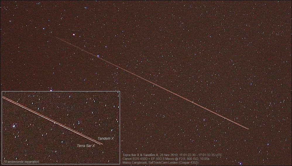
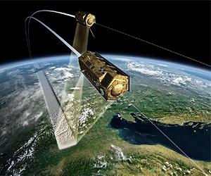
The TanDEM-X (TerraSAR-X Add-on for Digital Elevation Measurement) mission will create a global Digital Elevation Model (DEM) with unprecedented accuracy. TanDEM-X is a companion satellite to the existing and highly successful TerraSAR-X satellite and, with the two satellites flying in a tandem formation, data from each radar system will be used to build up the Digital Elevation Model.
The Digital Elevation Model data will be collected during the first 3 years of TanDEM-X’s operations and the nominal imaging capability of the TerraSAR-X mission will be continued. During this period a DEM area up to 150 million km² with a 2 m height resolution will be collected and made available to scientists and commercial users. Uses range from relief maps, precision farming or safety applications.
The major design changes of TanDEM-X compared to TerraSAR-X are the Inter-Satellite Link equipment and the Cold Gas System. The Inter-Satellite Link allows reception of TerraSAR-X status and position/velocity data from its S-band telemetry which are used on-board TanDEM-X to suppress radar transmission and orbit maneuvers in critical situations and to feed autonomous formation flying algorithms.
 |
|
The main payload is the active phased array X-Band Synthetic Aperture Radar (SAR) at 9.65 GHz which allows for weather-independent Earth imaging day or night. 3 basic modes of operation are used:
TanDEM-X has an additional high-pressure nitrogen gas propulsion system. This cold gas system provides smaller impulses than the hydrazine system (used on both satellites for orbit maintenance) and supports formation flying by fine orbit control of the TanDEM-X satellite. Using this system, TanDEM-X and TerraSAR-X will fly together in a helix orbit which is passively safe so that the satellites drift apart in case of no maneuvers. TanDEM-X has an autonomous formation flying control capability which may be used operationally after in-orbit validation.
The SARs on both satellites have the same design which allows exchange of synchronisation pulses to provide inter-SAR coherence. Both satellites have the same Tracking, Occultation and Ranging equipment provided by the GeoForschungsZentrum Potsdam (GFZ) which allows Precise Orbit Determination (POD) to give the radar baseline needed to generate interferometric data for DEMs.
Links:
---------- Post added at 19:50 ---------- Previous post was at 18:55 ----------
TO BE CONTINUED... (because of 15 images limit in a post)
The TanDEM-X (TerraSAR-X Add-on for Digital Elevation Measurement) mission will create a global Digital Elevation Model (DEM) with unprecedented accuracy. TanDEM-X is a companion satellite to the existing and highly successful TerraSAR-X satellite and, with the two satellites flying in a tandem formation, data from each radar system will be used to build up the Digital Elevation Model.
The Digital Elevation Model data will be collected during the first 3 years of TanDEM-X’s operations and the nominal imaging capability of the TerraSAR-X mission will be continued. During this period a DEM area up to 150 million km² with a 2 m height resolution will be collected and made available to scientists and commercial users. Uses range from relief maps, precision farming or safety applications.
Customer:
|{colsp=2} DLR (Deutsches Zentrum für Luft- und Raumfahrt)Mission:
|{colsp=2} To generate a global Digital Elevation Model (DEM) with unprecedented accuracyOrbit:
|{colsp=2} Sun-synchronous dusk-dawn orbitSpacecraft:
|{colsp=2} Rebuild of the TerraSAR-X satellite which was based on the Astrium Flexbus concept and extensive heritage from the CHAMP and GRACE missionsPayload:
|{colsp=2}
- Active phased array X-band Synthetic Aperture Radar (SAR)
- Tracking, Occultation and Ranging (TOR) equipment
Features:
|{colsp=2}
- X-band downlink horn antenna is mounted at the tip of a 3.3 m long boom
- Solid state mass memory capacity is 768 Gbit
- High-pressure nitrogen gas propulsion system for formation flying
Launch Mass:
|{colsp=2} 1340kg (spacecraft: 1220 kg, fuel: 120 kg)Dimensions:
|{colsp=2} 5 m length, 2.4 m diameter (hexagonal cross section)Launch Vehicle:
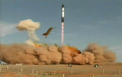
|{colsp=2} ISC Kosmotras
DNEPR-1 (RS-20 ICBM) rocket
Launch Site:
|{colsp=2} Baikonur Cosmodrome Silo 109/95, KazakhstanLaunch Date:
| June 21, 2010 02:14:03 UTC (06:14:03 MSD / 10:14:03 p.m. EDT on 20th)|
L[eventtimer]2010-6-21 2:14:03;%c%%ddd%/%hh%:%mm%:%ss%[/eventtimer]
Launch Window:
|{colsp=2} 02:00-02:28 UTC (04:00-04:28 CEST / 06-00-06:28 MSD / 10:00-10:28 p.m. EDT on 20th)Orbit:
|{colsp=2} polar-synchronous, PeA: 514 km, Ecc: 0, Inc: 98°Mission Duration:
|{colsp=2} 5 yearsThe major design changes of TanDEM-X compared to TerraSAR-X are the Inter-Satellite Link equipment and the Cold Gas System. The Inter-Satellite Link allows reception of TerraSAR-X status and position/velocity data from its S-band telemetry which are used on-board TanDEM-X to suppress radar transmission and orbit maneuvers in critical situations and to feed autonomous formation flying algorithms.
 |
|

The main payload is the active phased array X-Band Synthetic Aperture Radar (SAR) at 9.65 GHz which allows for weather-independent Earth imaging day or night. 3 basic modes of operation are used:
- StripMap (standard mode) which gives an on-ground resolution of 3 meters and a measurement swath width of 30 km
- Spotlight mode with an azimuth (along track) scanning to give a resolution of 1 meter with measurement scene ‘patches’ of 10 km x 10 km
- ScanSAR mode with elevation (across track) scanning to give a resolution of 16 meters and a measurement swath width of 100 km
TanDEM-X has an additional high-pressure nitrogen gas propulsion system. This cold gas system provides smaller impulses than the hydrazine system (used on both satellites for orbit maintenance) and supports formation flying by fine orbit control of the TanDEM-X satellite. Using this system, TanDEM-X and TerraSAR-X will fly together in a helix orbit which is passively safe so that the satellites drift apart in case of no maneuvers. TanDEM-X has an autonomous formation flying control capability which may be used operationally after in-orbit validation.
The SARs on both satellites have the same design which allows exchange of synchronisation pulses to provide inter-SAR coherence. Both satellites have the same Tracking, Occultation and Ranging equipment provided by the GeoForschungsZentrum Potsdam (GFZ) which allows Precise Orbit Determination (POD) to give the radar baseline needed to generate interferometric data for DEMs.
Links:
- TanDEM-X: A New High Resolution Interferometric SAR Mission
- EADS astrium TanDEM-X Blog entry
 TanDEM-X fact sheet (PDF)
- German TanDEM-X radar satellite now complete
- TerraSAR-X's 'twin' satellite, TanDEM-X, certified ready for space
- TanDEM-X awaits Lift-Off in Baikonur
---------- Post added at 19:50 ---------- Previous post was at 18:55 ----------
TanDEM-X satellite was delivered to Baikonur on 12 May 2010.

Unloading from the transport container.

Fuelling of the satellite with hydrazine.

At Baikonur, TanDEM-X has been prepared for further integration with the upper composite.


On the bottom, "Tandi" - a crocodile mascot of the mission.

Unloading from the transport container.
Fuelling of the satellite with hydrazine.
At Baikonur, TanDEM-X has been prepared for further integration with the upper composite.
On the bottom, "Tandi" - a crocodile mascot of the mission.
TO BE CONTINUED... (because of 15 images limit in a post)
Last edited: