OrbitHangar
Addon Comments
- Joined
- Apr 9, 2008
- Messages
- 3,832
- Reaction score
- 18
- Points
- 0

Author: enjo
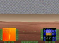
Displays a topographic map in grayscale and RGB.
Load the provided scenario files for some interesting places where Topo Map MFD is really useful.
Warning: This MFD is experimental and works only for Orbiter2016 and Jarmonik's DX9 2.1 client
Update: Uses cache for faster refreshes of elevation data.
Requires:
Microsoft Visual C++ 2005 Service Pack 1 Redistributable
Copyright 2015 by "Topper" - Original author: concept, calculations
Copyright 2015-8 by Szymon Ender "Enjo" (http://www.enderspace.de) - Co-developer: optimizations, putting it together
Many thanks to Jarmonik for helping in a smooth integration with his client!
Released under the terms of the LGPL v3:
http://www.gnu.org/licenses/lgpl.txt
DOWNLOAD
")
") computational complexity, because it's still O((width/3)*(height/3)) . Maybe in next iteration. I will be having some more time in the next week.
computational complexity, because it's still O((width/3)*(height/3)) . Maybe in next iteration. I will be having some more time in the next week.