Launch News Cryosat Mission News

orb

New member
News Reporter
Joined
Oct 30, 2009
Messages
14,020
Reaction score
4
Points
0
BBC News: Cryosat ice mission returns first science:
The Cryosat-2 spacecraft has produced its first major science result.

Radar data from the European satellite has been used to make a map of ocean circulation across the Arctic basin.

{...}


arctic_currents4_976_1.jpg
 

orb

New member
News Reporter
Joined
Oct 30, 2009
Messages
14,020
Reaction score
4
Points
0
ESA Portal: CryoSat ice data now open to all:
1 February 2011

Scientists can now tap into a flow of new data that will help to determine exactly how Earth's ice is changing. This information from ESA's CryoSat mission is set to make a step change in our understanding of the complex relationship between ice and climate.

Considering the loss of the original CryoSat satellite during launch in 2005, scientists around the world have had a long wait for information on ice thickness – making the release even more of a milestone for the mission.

{...}

Launched in April last year, CryoSat and the ground processing set-up have shown to be in excellent working order.

Prof. Duncan Wingham from University College London said, "It’s great to see the data go out on general release, and it is a measure of the efforts from the ESA team that this has been achieved so soon after launch.

"We already know that the hardware is providing extremely accurate results; now we can start to see that translate into real scientific achievements."

{...}
 

orb

New member
News Reporter
Joined
Oct 30, 2009
Messages
14,020
Reaction score
4
Points
0
ESA: CryoSat rocking and rolling:
17 October 2011

ESA’s ice satellite is rolling left and right in orbit to help it continue its precise measurements of the vast ice sheets that blanket Greenland and Antarctica.

Since its launch 18 months ago, CryoSat-2 has been collecting data to improve our understanding of the relationship between ice and climate.

Just this year, the first map of Arctic sea-ice thickness was unveiled, and the satellite will continue to monitor the changing ice for years to come.

To ensure the precision of the measurements, an operation is under way to roll the satellite from side to side as it flies over the flat oceans.

This manoeuvre is to calibrate CryoSat’s radar altimeter for measuring ice thickness, especially over the margins of ice sheets.

{...}
 

orb

New member
News Reporter
Joined
Oct 30, 2009
Messages
14,020
Reaction score
4
Points
0
ESA: CryoSat ice satellite rides new waves:
22 December 2011

ESA’s CryoSat mission has been gathering detailed information on the thickness of Earth’s ice since its launch in 2010. Through international collaboration, this state-of-the-art mission is soon to be used to monitor conditions at sea for marine forecasting.

{...}


Click on images to enlarge​
Estimate of wind speed over oceans using data from ESA’s CryoSat mission from 17 November – 13 December. The product was generated by NOAA using CryoSat’s fast delivery mode radar echoes.
Credits: NOAA – E. Leuliette​
 

Wave-height from CryoSat delivered in less than three hours. The image is taken from a forecaster’s screen at NOAA’s Centre for Environmental Prediction. These data are consistent with measurements from altimeters on the Envisat and Jason satellites.
Credits: NOAA – J. Sienkiewicz​
 

Sea level off the southeast coast of Australia on 15 December 2011 by combining CryoSat data with Envisat, Jason 1 and Jason 2.
Credits: CSIRO - D. Griffen​


orb

New member
News Reporter
Joined
Oct 30, 2009
Messages
14,020
Reaction score
4
Points
0
ESA
Checking CryoSat reveals rising Antarctic blue ice

29 March 2012

Field measurements in the spectacular blue ice region of Antarctica not only provide confidence in the accuracy of ESA’s CryoSat mission, but have also shown that this part of the ice sheet has increased in height.

Click on image to enlarge​
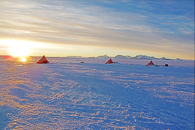
Validating the data from ESA’s CryoSat ice mission takes scientists to some of the most inhospitable places on Earth. This photo shows the camp where scientists spend around three months at a time taking measurements in the blue ice region of Antarctica.
Credits: TU Dresden​


Making sure that CryoSat is delivering accurate data to work out precisely how the thickness of Earth’s ice is changing is a continuing effort, and one that takes teams of scientists to some of the harshest environments on the planet.

These particular campaigns were carried out on a desolate plateau known as the blue ice region, which lies on the edge of Antarctica. As its name suggests, this unique region features a vast expanse of polished blue ice, devoid of snow.

Click on image to enlarge​
Antarctica showing the location of the blue ice region where come of the validation activities to support ESA's CryoSat mission are being carried out.
Credits: ESA​


It is precisely this lack of snow and unusual icy surface that makes the region very useful for determining the accuracy of CryoSat’s radar altimeter.

The lack of snow in this part of Antarctica means that radar signals emitted by CryoSat’s altimeter bounce straight off the glistening ice and back to the satellite.

The height of the ice is then determined from the difference in time between the signal being emitted and received.

Since ice is usually covered by a layer of snow, the signal normally has to penetrate this top layer before reaching the ice – a fact that might influence CryoSat’s measurements of ice height.

Measurements from the hard shiny surface of the blue ice are therefore extremely valuable for checking against CryoSat’s data.

While the field experiments are designed for validation purposes, the analysis of measurements from two campaigns in 2008–09 and 2010–11 has shown some surprising results: it reveals that this part of Antarctica actually increased in height by an average of 9 cm between the two periods.

Click on image to enlarge​
Analysis of the data collected in ESA campaigns, which started in 2008, along with other datasets going back 20 years, reveal that this part of Antarctica increased in height by 9 cm between 2008 and 2010.
Credits: ESA/M. Davidson​


Scientists from the Technical University (TU) of Dresden braved extreme weather to map subtle changes in the height of the ice over 2500 sq km. The measurements were taken on the ground with sophisticated GPS equipment towed by snowmobiles.

Scientists from the Alfred Wegner Institute also took measurements from an aircraft with an instrument that simulates CryoSat’s radar altimeter.

After analysis of the data collected in the campaigns, and the fact that other datasets going back 20 years are available, the scientists determined changes in the height of the ice for three different periods.

Click on image to enlarge​
Taking measurements of the height of the blue ice region in Antarctica. A sensor is mounted on the sledge pulled by the snowmobile.
Credits: TU Dresden​


In 1991–2000, there was a drop of about 5 cm, a trend that continued in 2000–08. However, the third period in 2008–10 shows this unexpected rise.

Reinhard Dietrick from TU Dresden said, “This interesting result showing the reversal in height is thanks to the campaigns before the launch of CryoSat in 2010.

“The results are, of course, preliminary but with this reversal in mind, it would be very interesting to see if the increase in height remains in the future.”

Click on image to enlarge​
ESA’s Earth Explorer CryoSat mission is dedicated to precise monitoring of changes in the thickness of marine ice floating in the polar oceans and variations in the thickness of the vast ice sheets that blanket Greenland and Antarctica.
Credits: ESA/AOES Medialab​


At the other end of the planet, another campaign dedicated to CryoSat is taking off this week. Teams from ESA, NASA, Europe and Canada are now converging in the high Arctic to take measurements from the ice and from the air as CryoSat orbits above.

{...}
 

orb

New member
News Reporter
Joined
Oct 30, 2009
Messages
14,020
Reaction score
4
Points
0
ESA:
Latest CryoSat result revealed

24 April 2012

After nearly a year and a half of operations, CryoSat has yielded its first seasonal variation map of Arctic sea-ice thickness. Results from ESA’s ice mission were presented today at the Royal Society in London.

In June 2011, the first map of Arctic sea-ice thickness was unveiled, using CryoSat data acquired between January and February of that year.

Now, the complete 2010–11 winter season data have been processed to produce a seasonal variation map of sea-ice thickness.

This is the first map of its kind generated using data from a radar altimeter at such a high resolution compared to previous satellite measurements.

CryoSat’s altimeter makes precise measurements of its height above the ice by measuring the time interval between the transmission and reception of very short radar pulses.

Readings over the Arctic from October 2010 to March 2011 were processed to map the seasonal formation of floating ice.

ESA and NASA have been collaborating to perform carefully coordinated flights directly under CryoSat’s orbit over the Arctic, gathering data to ensure the accuracy of the satellite measurements.

This first validated CryoSat dataset demonstrates the full potential of this innovative ice mission.


Owing to the high rate of change in the Arctic Ocean, this has a special relevance for climate change research.

Other significant results from this collaborative European mission will be presented and discussed, with perspectives from UK industrial and scientific communities.

This event is being jointly organised by ESA and the UK Space Agency as part of the wider celebration of the 50th anniversary of the UK in space.


The map, along with a full digital elevation model of Greenland and other scientific results from the collaborative European mission, were presented today at the Royal Society in London.

The event was jointly organised by ESA and the UK Space Agency as part of the wider celebration of the 50th anniversary of the UK in space.

“Within the 50th anniversary celebrations of space activities in the UK, we have today seen how the UK has been able to contribute to and lead in the many aspects of ESA’s CryoSat mission,” said David Williams, Chief Executive of the UK Space Agency.

Director of ESA’s Earth Observation Programmes, Volker Liebig, outlined the dramatic effects that climate change has had on the Arctic, and how satellites have been monitoring sea-ice for over 30 years.

"In the coming years, the Arctic will become a very important geo-political region," said Prof. Liebig.

"15 to 20 per cent of the world’s oil and gas reserves are expected there, and we will find shorter shipping routes as the ice melts. Satellites will play and ever-important role in the sustainable management of this sensitive region."


Every year, the Arctic Ocean experiences the seasonal formation and then melting of vast amounts of floating ice. Over the past decade, satellites have seen an acceleration in the rate of overall sea ice loss.

Radars on satellites such as ESA’s CryoSat can acquire high-resolution images through clouds and darkness. This is particularly useful when observing the inaccessible Arctic, which is prone to long periods of bad weather and extended darkness.

In the coming years, CryoSat data will map precise changes in sea-ice thickness year to year, furthering our understanding of the effects that climate change has on the Arctic.

ESA’s SMOS mission is providing complementary information on sea-ice cover and the thickness of thin ice.
 

orb

New member
News Reporter
Joined
Oct 30, 2009
Messages
14,020
Reaction score
4
Points
0
ESA: Cryosat Hits Land:
21 December 2012

ESA’s ice mission is now giving scientists a closer look at oceans, coastal areas, inland water bodies and even land, reaching above and beyond its original objectives.


CryoSat altimeter view of sea level and topography over the Caribbean Sea and Cuba. The image shows radar reflections that differ in intensity between the water and elevated land. Near the edges of the island, points of high radar reflections are pictured in red. This is due to the higher reflectiveness of calm waters of the bay and over coral reefs.

{...}
 

Notebook

Addon Developer
Addon Developer
News Reporter
Donator
Joined
Nov 20, 2007
Messages
11,816
Reaction score
641
Points
188
http://www.bbc.co.uk/news/science-environment-36272728

European scientists have found a way to super-charge their study of the ice sheets in Antarctica and Greenland.

The novel technique boosts the data about height changes that are gathered by radar instruments on satellites.

Known as swath altimetry, it permits researchers to see broader regions of the ice sheets in any one pass overhead, and at a much finer scale.

Areas of melting or accumulation can now be investigated with 100 times more information.
 

Notebook

Addon Developer
Addon Developer
News Reporter
Donator
Joined
Nov 20, 2007
Messages
11,816
Reaction score
641
Points
188
http://www.esa.int/Our_Activities/Observing_the_Earth/CryoSat/Secrets_of_hidden_ice_canyons_revealed

11 October 2017
We are all aware that Antarctica’s ice shelves are thinning, but recently scientists have also discovered huge canyons cutting through the underbelly of these shelves, potentially making them even more fragile. Thanks to the CryoSat and Sentinel-1 missions, new light is being shed on this hidden world.
Antarctica is surrounded by ice shelves, which are thick bands of ice that extend from the ice sheet and float on the coastal waters. They play an important role in buttressing the ice sheet on land, effectively slowing the sheet’s flow as it creeps seaward.
 

Notebook

Addon Developer
Addon Developer
News Reporter
Donator
Joined
Nov 20, 2007
Messages
11,816
Reaction score
641
Points
188

Notebook

Addon Developer
Addon Developer
News Reporter
Donator
Joined
Nov 20, 2007
Messages
11,816
Reaction score
641
Points
188
May 2018
While ESA’s CryoSat continues to provide clear insight into how much sea ice is being lost and how the Antarctic and Greenlandic ice sheets are changing, the mission has again surpassed its original scope by revealing exactly how mountain glaciers are also succumbing to change.
Glaciers all over the globe are retreating – and for the last 15 years, glacial ice has been the main cause of sea-level rise.

http://www.esa.int/Our_Activities/O...ryoSat_reveals_retreat_of_Patagonian_glaciers
 

Notebook

Addon Developer
Addon Developer
News Reporter
Donator
Joined
Nov 20, 2007
Messages
11,816
Reaction score
641
Points
188
Title Antarctica detailed in 3D
Released 14/05/2019 12:18 pm
Copyright University of Edinburgh
Description
Unfortunately ice is a hot topic when it comes to understanding and monitoring how this fragile component of the Earth system is being affected by climate change. Scientists, therefore, go to great lengths to study changes happening in the remote icy reaches of our planet – a subject that is being discussed in detail at this week’s Living Planet Symposium in Italy. Among the results being presented is a novel 3D dataset of Antarctica. Scientists from the University of Edinburgh, UK, created this new view by processing data from ESA’s CryoSat in a clever way.
CryoSat carries a radar altimeter that measures the height of the world’s ice. Typically, the data are used to map the height of ice at single points. And, since it was launched in 2010, this has revealed much about how ice sheets, glaciers and sea ice are changing.

http://www.esa.int/spaceinimages/Images/2019/05/Antarctica_detailed_in_3D
 

Notebook

Addon Developer
Addon Developer
News Reporter
Donator
Joined
Nov 20, 2007
Messages
11,816
Reaction score
641
Points
188
5 August 2019
The rapidly changing climate in the Arctic is not only linked to melting glaciers and declining sea ice, but also to thinning ice on lakes. The presence of lake ice can be easily monitored by imaging sensors and standard satellite observations, but now adding to its list of achievements, CryoSat can be used to measure the thickness of lake ice – another indicator of climate change.
CryoSat, one of ESA’s Earth Explorer satellites, carries the first radar altimeter of its kind. The instrument is traditionally used to determine the thickness of sea ice floating in oceans and to monitor changes in vast ice sheets on land, providing evidence of Earth’s diminishing polar ice.
Lakes in North America’s Arctic and sub-Arctic regions cover between 15% and 40% of the landscape, and play an important role in the region’s climate. They are also a vital resource for both society and an important habitat for aquatic wildlife.

http://www.esa.int/Our_Activities/Observing_the_Earth/CryoSat/CryoSat_conquers_ice_on_Arctic_lakes
 

Notebook

Addon Developer
Addon Developer
News Reporter
Donator
Joined
Nov 20, 2007
Messages
11,816
Reaction score
641
Points
188
Today marks 10 years since a Dnepr rocket blasted off from an underground silo in the remote desert steppe of Kazakhstan, launching one of ESA’s most remarkable Earth-observing satellites into orbit. Tucked safely within the rocket fairing, CryoSat had a tough job ahead: to measure variations in the height of Earth’s ice and reveal how climate change is affecting the polar regions. Carrying novel technology, this extraordinary mission has led to a wealth of scientific discoveries that go far beyond its primary objectives to measure polar ice. And, even at 10 years old, this incredible mission continues to surpass expectations.

www.esa.int/Applications/Observing_the_Earth/CryoSat/CryoSat_still_cool_at_10
 
Top